IMAGES TAKEN NEAR TO
Nutbrook Street, LONDON, SE15 4JU
Introduction
This page details the photographs taken nearby to Nutbrook Street, SE15 4JU by members of the Geograph project.
The Geograph project started in 2005 with the aim of publishing, organising and preserving representative images for every square kilometre of Great Britain, Ireland and the Isle of Man.

There are currently over 7.5m images from over14,400 individuals and you can help contribute to the project by visiting https://www.geograph.org.uk
Image Map
Images are licensed for reuse under creativecommons.org/licenses/by-sa/2.0
Notes
- Clicking on the map will re-center to the selected point.
- The higher the marker number, the further away the image location is from the centre of the postcode.
Image Listing (71 Images Found)
Images are licensed for reuse under creativecommons.org/licenses/by-sa/2.0
Image
Details
Distance

4
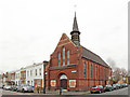
Amott Baptist Church, East Church
On Amott Road.
Image: © David Anstiss
Taken: 25 Sep 2011
0.08 miles
6
St Andrew's Mission Church, Waghorn Street
Image: © John Salmon
Taken: 24 Jan 2014
0.11 miles
7
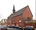
St Andrew's Mission Church, Waghorn Street
Image: © John Salmon
Taken: 24 Jan 2014
0.11 miles
8
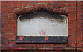
St Andrew's Mission Church, Waghorn Street - Foundation stone
Architect J Nixon Horsefield, built 1903
Image: © John Salmon
Taken: 24 Jan 2014
0.11 miles
9
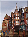
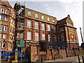
St John's and St Clements school, East Dulwich
Grade II listed Secondary school on Adys Road. Was formerly known as Ady's Road Board School.
See http://www.britishlistedbuildings.co.uk/en-470531-st-johns-and-st-clements-school-camberwe for more details on the building.
Image: © David Anstiss
Taken: 25 Sep 2011
0.12 miles
10
St Johns and St Clements School
Grade II listed Secondary school on Adys Road. Was formerly known as Ady's Road Board School.
See Link for more details on the building.
Image: © David Anstiss
Taken: 25 Sep 2011
0.12 miles