IMAGES TAKEN NEAR TO
Muschamp Road, LONDON, SE15 4EF
Introduction
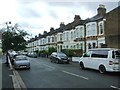
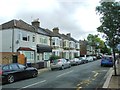
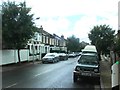
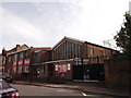
This page details the photographs taken nearby to Muschamp Road, SE15 4EF by members of the Geograph project.
The Geograph project started in 2005 with the aim of publishing, organising and preserving representative images for every square kilometre of Great Britain, Ireland and the Isle of Man.

There are currently over 7.5m images from over14,400 individuals and you can help contribute to the project by visiting https://www.geograph.org.uk
Image Map
Images are licensed for reuse under creativecommons.org/licenses/by-sa/2.0
Notes
- Clicking on the map will re-center to the selected point.
- The higher the marker number, the further away the image location is from the centre of the postcode.
Image Listing (75 Images Found)
Images are licensed for reuse under creativecommons.org/licenses/by-sa/2.0
Image
Details
Distance
3
Amott Baptist Church, East Church
On Amott Road.
Image: © David Anstiss
Taken: 25 Sep 2011
0.09 miles
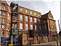
4
St John's and St Clements school, East Dulwich
Grade II listed Secondary school on Adys Road. Was formerly known as Ady's Road Board School.
See http://www.britishlistedbuildings.co.uk/en-470531-st-johns-and-st-clements-school-camberwe for more details on the building.
Image: © David Anstiss
Taken: 25 Sep 2011
0.09 miles
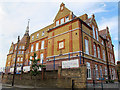
5
St Johns and St Clements School
Grade II listed Secondary school on Adys Road. Was formerly known as Ady's Road Board School.
See Link for more details on the building.
Image: © David Anstiss
Taken: 25 Sep 2011
0.10 miles
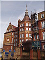
6
St John's and St Clement's Primary School
A late Victorian board school (1883) by architect T J Bailey, originally called the Ady's Road Board School and relaunched under a new name at some time. The building is listed grade 2 (list entry number 1376529). It is surprising that both this and Bailey's other school for the School Board for London only a few hundred metres away Image are still open.
Image: © Stephen Craven
Taken: 30 Aug 2013
0.10 miles
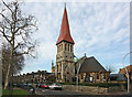
8
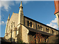
St John's church, East Dulwich: west end
Like many churches, it is difficult to get a good photo of the whole building because of the buildings and trees surrounding it. This is the west end of the church, which is on the north side of Goose Green. The church was originally built in 1865, but almost completely destroyed in World War 2 and rebuilt by Sebastian Comper, reopening in 1951.
Image: © Stephen Craven
Taken: 8 Oct 2008
0.12 miles
9
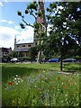
St John the Evangelist Church, Goose Green
The church was consecrated in 1865. The architect was Charles Baily who designed the church in the Gothic style of the Middle Ages. It was very badly damaged by incendiary bombs during the Second World War when the roof, much of the stained glass and internal decorations were lost. The tower, spire and apse though survived as did the clock which dates from 1864.
St John's was restored after the War by J. B. Sebastian Comper, the son of Sir Ninian Comper who designed many of the features used in the restoration of building, including much of the Lady Chapel.
The show of cornfield annuals in the foreground are on Goose Green - see also https://www.geograph.org.uk/photo/6210898
Image: © Marathon
Taken: 30 Jun 2019
0.12 miles