IMAGES TAKEN NEAR TO
Rye Lane, LONDON, SE15 4BQ
Introduction
This page details the photographs taken nearby to Rye Lane, SE15 4BQ by members of the Geograph project.
The Geograph project started in 2005 with the aim of publishing, organising and preserving representative images for every square kilometre of Great Britain, Ireland and the Isle of Man.

There are currently over 7.5m images from over14,400 individuals and you can help contribute to the project by visiting https://www.geograph.org.uk
Image Map
Images are licensed for reuse under creativecommons.org/licenses/by-sa/2.0
Notes
- Clicking on the map will re-center to the selected point.
- The higher the marker number, the further away the image location is from the centre of the postcode.
Image Listing (111 Images Found)
Images are licensed for reuse under creativecommons.org/licenses/by-sa/2.0
Image
Details
Distance
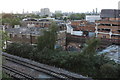
1
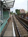
Peckham Rye station
Peckham Rye railway station opened on 1st December 1865 for London, Chatham & Dover Railway trains and on 13th August 1886 for London Brighton & South Coast Railway trains. It was designed by Charles Henry Driver (1832–1900), the architect of Abbey Mills and Crossness Pumping Stations, who also designed the grade II listed Denmark Hill and Battersea Park stations between here and Victoria. Peckham Rye is almost two separate stations, linked by a booking hall. This view is from the southern (London, Chatham & Dover Railway) platform and looks across the bridge over Rye Lane.
Image: © Marathon
Taken: 31 Aug 2011
0.02 miles
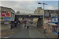
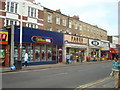
4
117-125 Rye Lane, Peckham
There are a number of vaguely Art Deco buildings in Rye Lane in the environs of Peckham Rye railway station. This example is a post-war building, and was first occupied by the retailer C & A.
Image: © Jim Osley
Taken: 13 Jan 2016
0.02 miles
5
Peckham Coal Siding
This is taken from the roof of the Bussey Building. The foliage alongside the railway line is the site of the old coal siding. There is a project to clear this and open the route up for pedestrians.
Image: © Robert Eva
Taken: 24 May 2016
0.03 miles
6
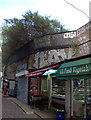
Peckham Coal Siding from ground level
This alley between the two railway lines at Peckham Rye once led to the coal depot where wagon loads of coal were unloading from the siding above and transferred to ground level via a hoist next to the line. Closed in 1961 but part of the old coal merchant's sign (in Southern Region green) can still be seen.
Image: © Robert Eva
Taken: 23 May 2016
0.03 miles
9
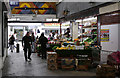
Arcade - Rye Lane
Fruit and vegetables on sale in the Arcade that provides pedestrian access to Peckham Rye Station from Rye Lane through a 'between the wars' retail development that hides the main station building from view. Rye Lane has been classified a 'Conservation Area' by Southwark Council and I understand that the retailers in this building are under threat of eviction (2015).
Image: © Martin Addison
Taken: 16 Apr 2015
0.03 miles
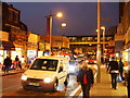
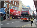
10
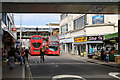
Rye Lane
With a wide variety of local traders, Rye Lane is a vibrant part of the community in Peckham. In this photo we see the 'between the wars' (1920's/30's) purpose built retail premises occupying the area between the bridges of the railway lines to the east of Peckham Rye station - now given over to several individual retailers. Rye Lane has been classified a 'Conservation Area' by Southwark Council.
Image: © Martin Addison
Taken: 16 Apr 2015
0.04 miles