IMAGES TAKEN NEAR TO
Kimberley Avenue, LONDON, SE15 3XH
Introduction
This page details the photographs taken nearby to Kimberley Avenue, SE15 3XH by members of the Geograph project.
The Geograph project started in 2005 with the aim of publishing, organising and preserving representative images for every square kilometre of Great Britain, Ireland and the Isle of Man.

There are currently over 7.5m images from over14,400 individuals and you can help contribute to the project by visiting https://www.geograph.org.uk
Image Map
Images are licensed for reuse under creativecommons.org/licenses/by-sa/2.0
Notes
- Clicking on the map will re-center to the selected point.
- The higher the marker number, the further away the image location is from the centre of the postcode.
Image Listing (111 Images Found)
Images are licensed for reuse under creativecommons.org/licenses/by-sa/2.0
Image
Details
Distance
1
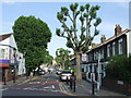
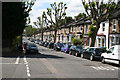
Kimberley Avenue, Nunhead
Kimberley Avenue, looking east from the junction with Evelina Road.
Image: © Malc McDonald
Taken: 27 Jun 2010
0.02 miles
2
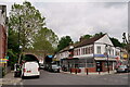
Nunhead
The junction of Evelina Road and Kimberley Avenue. The railway station lies to the right of this location.
Image: © Peter Trimming
Taken: 23 May 2023
0.04 miles
3
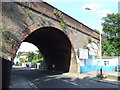
Railway arch near Nunhead station
Railway arch over Evelina Road, Nunhead.
Image: © Malc McDonald
Taken: 27 Jun 2010
0.05 miles
5
Nunhead: Kimberley Avenue
Looking west along this pleasant tree-lined road
Image: © Dr Neil Clifton
Taken: 18 Jun 2012
0.06 miles
7
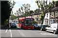
Nunhead: Kimberley Avenue
Looking west. The London Central single-decker is on local route P12, which runs between Honor Oak Park and Surrey Quays by a very complicated (and interesting) route.
Image: © Dr Neil Clifton
Taken: 18 Jun 2012
0.07 miles
8
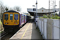
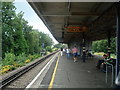
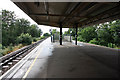
Nunhead Station
The station was built by the Southern Railway in 1925 as part of the electrification of the route. It replaced the original Nunhead Junction station which was situated on the opposite side of Gibbon Road. There are some characteristic Southern Railway features on display - the W-shaped platform awning and the concrete fence panels are typical of that railway company. Interestingly, beyond the central area of the station and its awning the platforms are separate - presumably a cost saving measure.
The train in the photo is the 10:27 (2E25) Thameslink service to Sevenoaks. Formed of two Class 319 units (319429 closest to camera) it departed West Hampstead Thameslink at 09:50 and is due in Sevenoaks at 11:13.
Image: © Martin Addison
Taken: 16 Apr 2015
0.07 miles
9
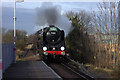
Steam special at Nunhead
Britannia Pacific 70013, Oliver Cromwell hauls the Cathedrals Express through Nunhead on its way to Dover.
Image: © Robert Eva
Taken: 14 Feb 2018
0.07 miles
