IMAGES TAKEN NEAR TO
Carden Road, LONDON, SE15 3UD
Introduction
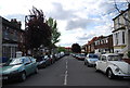
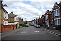
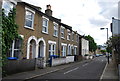
This page details the photographs taken nearby to Carden Road, SE15 3UD by members of the Geograph project.
The Geograph project started in 2005 with the aim of publishing, organising and preserving representative images for every square kilometre of Great Britain, Ireland and the Isle of Man.

There are currently over 7.5m images from over14,400 individuals and you can help contribute to the project by visiting https://www.geograph.org.uk
Image Map
Images are licensed for reuse under creativecommons.org/licenses/by-sa/2.0
Notes
- Clicking on the map will re-center to the selected point.
- The higher the marker number, the further away the image location is from the centre of the postcode.
Image Listing (102 Images Found)
Images are licensed for reuse under creativecommons.org/licenses/by-sa/2.0
Image
Details
Distance
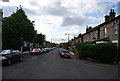
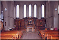
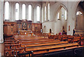
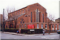
8
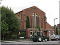
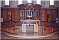
The Lighthouse Cathedral
That is the present name of this church, which was built in 1957 to the designs of Lawrence King as St Anthony's (Church of England). It was listed grade 2 in 1972 but became surplus to requirements and was declared redundant in 2001 and sold to its present owners. The previous church on the site (destroyed by bombing in 1940) was called St Antholin's and built in 1878.
Image: © Stephen Craven
Taken: 20 Aug 2008
0.05 miles