IMAGES TAKEN NEAR TO
Scylla Road, LONDON, SE15 3RZ
Introduction
This page details the photographs taken nearby to Scylla Road, SE15 3RZ by members of the Geograph project.
The Geograph project started in 2005 with the aim of publishing, organising and preserving representative images for every square kilometre of Great Britain, Ireland and the Isle of Man.

There are currently over 7.5m images from over14,400 individuals and you can help contribute to the project by visiting https://www.geograph.org.uk
Image Map
Images are licensed for reuse under creativecommons.org/licenses/by-sa/2.0
Notes
- Clicking on the map will re-center to the selected point.
- The higher the marker number, the further away the image location is from the centre of the postcode.
Image Listing (83 Images Found)
Images are licensed for reuse under creativecommons.org/licenses/by-sa/2.0
Image
Details
Distance
1
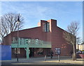
Nunhead community centre
Opened in January 2016, "The Green" replaced an older community centre nearby.
The silhouette is of Jenny Hill, a nineteenth century music hall performer and a local heroine.
Image: © Robert Eva
Taken: 17 Jan 2017
0.01 miles
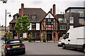
3
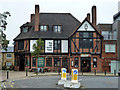
The Old Nun's Head, Nunhead Green, SE15
Image: © Robin Webster
Taken: 30 Oct 2011
0.03 miles
4
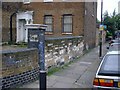
Relic of the Nunnery
This old stone wall on the corner of Gordon Road and Nunhead Green is said to be a relic from the nunnery that was dissolved by Henry VIII.
Image: © David Wright
Taken: 18 May 2001
0.03 miles
5
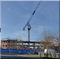
Nunhead Green, work in progress
New housing development on the West side of Nunhead Green
Image: © Robert Eva
Taken: 17 Jan 2017
0.03 miles
6
Doorway in Consort Road, Peckham
I have looked at old maps from before the First World War and do not know what this doorway was for.
Image: © Marathon
Taken: 5 Jul 2021
0.03 miles
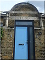
7

Consort Road Clinic, SE15, old centre block
This was built in 1901 as a relief station.
Image: © Robin Webster
Taken: 30 Oct 2011
0.03 miles
8

Consort Road Clinic, SE15
This was built in 1901 as a relief station, the centre block is so inscribed.
Image: © Robin Webster
Taken: 30 Oct 2011
0.03 miles
9
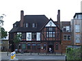
The Old Nun's Head, SE15
The Old Nun's Head pub, on Nunhead Green.
Image: © Malc McDonald
Taken: 27 Jun 2010
0.04 miles
10
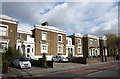
Terrace, Nunhead Lane
"A 2-storey, irregular, stock brick terrace, with richly detailed stucco dressings" http://www.southwark.gov.uk/download/4999/nunhead_green . Mid-C19.
Image: © Derek Harper
Taken: 11 Mar 2011
0.04 miles