IMAGES TAKEN NEAR TO
Whorlton Road, LONDON, SE15 3PD
Introduction
This page details the photographs taken nearby to Whorlton Road, SE15 3PD by members of the Geograph project.
The Geograph project started in 2005 with the aim of publishing, organising and preserving representative images for every square kilometre of Great Britain, Ireland and the Isle of Man.

There are currently over 7.5m images from over14,400 individuals and you can help contribute to the project by visiting https://www.geograph.org.uk
Image Map
Images are licensed for reuse under creativecommons.org/licenses/by-sa/2.0
Notes
- Clicking on the map will re-center to the selected point.
- The higher the marker number, the further away the image location is from the centre of the postcode.
Image Listing (82 Images Found)
Images are licensed for reuse under creativecommons.org/licenses/by-sa/2.0
Image
Details
Distance
1
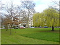
Peckham Rye
Looking across the northern tip of the large triangular green at Peckham Rye.
Image: © David Martin
Taken: 11 Mar 2011
0.05 miles
2
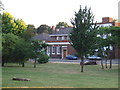
Peckham Rye Common
Trees on Peckham Rye Common.
Image: © Malc McDonald
Taken: 27 Jun 2010
0.06 miles
3
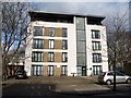
Tyrells Court, Peckham Rye
A recent block of 14 flats on Nunhead Lane, opposite the junction with Banfield Road.
Image: © Derek Harper
Taken: 11 Mar 2011
0.07 miles
4
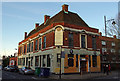
The Edinburgh Castle
Currently a restaurant, on the corner of Nunhead Lane and Old James Street. Compare with Image (2015).
Image: © Ian Taylor
Taken: 18 Jan 2020
0.10 miles
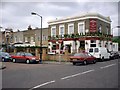
5
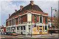
The Edinburgh Castle
Located on the corner of Nunhead Lane and Old James Street, this pub is currently closed (circa 2010). There looks to be some redecoration underway so perhaps it will reopen at some time in the future though that will probably be as a restaurant / bar - a role it has served in several guises in recent years. The building was designed by A.E.Sewell for Truman Hanbury Buxton and dates to the 1930's.
Image: © Martin Addison
Taken: 16 Apr 2015
0.10 miles
6
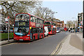
Peckham Rye - Bus Stand
Abellio London buses occupy the bus stand at Peckham Rye between duties on the 343 route. The route runs from City Hall to New Cross Gate but Peckham Rye forms a useful mid-point to turn vehicles in order to maintain service frequencies when traffic conditions cause delays. The closest vehicle in this image is receiving attention to a defect.
Image: © Martin Addison
Taken: 16 Apr 2015
0.11 miles
7
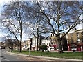
Peckham Rye
This island of trees at the northern end of the common is really an elongated roundabout, but an attractive one, with shops along the far side.
Image: © Derek Harper
Taken: 11 Mar 2011
0.11 miles
8
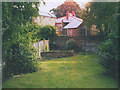
A back garden in Peckham
Peckham is associated with the grittiest type of urban living but it does have its quiet suburban streets, with tranquil gardens like this. Exact address withheld for security reasons.
Image: © Stephen Craven
Taken: Unknown
0.12 miles
9
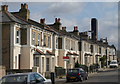
Philip Walk, Peckham Rye
These semis just off Peckham Rye are given elegance by the cornice under the eaves.
Image: © Derek Harper
Taken: 11 Mar 2011
0.12 miles
10
The Pyrotechnist Arms
The Pyrotechnist Arms, Nunhead.
Image: © David Wright
Taken: 9 Jun 2001
0.12 miles