IMAGES TAKEN NEAR TO
Peckham Rye, LONDON, SE15 3JQ
Introduction
This page details the photographs taken nearby to Peckham Rye, SE15 3JQ by members of the Geograph project.
The Geograph project started in 2005 with the aim of publishing, organising and preserving representative images for every square kilometre of Great Britain, Ireland and the Isle of Man.

There are currently over 7.5m images from over14,400 individuals and you can help contribute to the project by visiting https://www.geograph.org.uk
Image Map
Images are licensed for reuse under creativecommons.org/licenses/by-sa/2.0
Notes
- Clicking on the map will re-center to the selected point.
- The higher the marker number, the further away the image location is from the centre of the postcode.
Image Listing (75 Images Found)
Images are licensed for reuse under creativecommons.org/licenses/by-sa/2.0
Image
Details
Distance
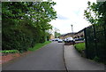
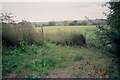
2
Brockley Footpath
Photo shows Brockley footpath descending towards Nunhead with the cemetery wall to the right and water works railings to the left.
Image: © David Wright
Taken: 6 Sep 1998
0.10 miles
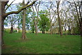
3
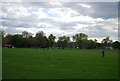
Rural Prospect - London SE15
Picture taken from Brockley footpath looking West over the water works site. Yes folks this is truly inner city London !
Image: © David Wright
Taken: 6 Sep 1998
0.10 miles
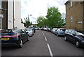
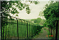
5
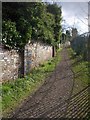
Brockley Footpath
A reverse view of Image, climbing steeply between cemetery and water works.
Image: © Derek Harper
Taken: 11 Mar 2011
0.13 miles