IMAGES TAKEN NEAR TO
Rye Road, LONDON, SE15 3AX
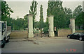
Introduction
This page details the photographs taken nearby to Rye Road, SE15 3AX by members of the Geograph project.
The Geograph project started in 2005 with the aim of publishing, organising and preserving representative images for every square kilometre of Great Britain, Ireland and the Isle of Man.

There are currently over 7.5m images from over14,400 individuals and you can help contribute to the project by visiting https://www.geograph.org.uk
Image Map
Images are licensed for reuse under creativecommons.org/licenses/by-sa/2.0
Notes
- Clicking on the map will re-center to the selected point.
- The higher the marker number, the further away the image location is from the centre of the postcode.
Image Listing (94 Images Found)
Images are licensed for reuse under creativecommons.org/licenses/by-sa/2.0
Image
Details
Distance
1
Bredinghurst School, Nunhead
This school on Stuart Road, is undergoing re-development.
Image: © David Anstiss
Taken: 25 Sep 2011
0.05 miles
2
Borland Road Depot
Picture shows Borland Rd. council depot. The rise behind is the water works and the ancient footpath to Nunhead passes between the depot railings and the brick wall of Nunhead cemetery.
Image: © David Wright
Taken: 23 Oct 2005
0.06 miles
3
Alleyway on Sartor Road
This alley leads to Inverton Road.
On the right is a school undergoing re-development.
Image: © David Anstiss
Taken: 25 Sep 2011
0.07 miles
5
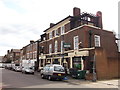
The Ivy House, public house, Nunhead
On Stuart Road.
Image: © David Anstiss
Taken: 25 Sep 2011
0.10 miles
6
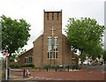
St Antony & St Silas, Ivydale Road, Nunhead
Image: © John Salmon
Taken: 14 Jul 2010
0.10 miles
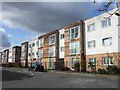
7
New houses on Ivydale Road (2)
A block of flats, contrasting with the contemporary town houses across the road Image
Image: © Stephen Craven
Taken: 18 Jan 2015
0.11 miles
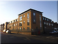
8
Housing on Borland Road, Nunhead
A distinctively-designed development of flats on the slopes of Nunhead Hill.
Image: © Derek Harper
Taken: 11 Mar 2011
0.11 miles
10
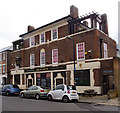
"The Ivy House" public house, Nunhead
A co-operatively owned public house - history at this http://www.ivyhousenunhead.com/about.php. Grade II listed - description at this https://historicengland.org.uk/listing/the-list/list-entry/1408530.
Architect A.E. Sewell for Truman's Brewery.
Image: © Jim Osley
Taken: 24 Nov 2016
0.11 miles