IMAGES TAKEN NEAR TO
Hollydale Road, LONDON, SE15 2TG
Introduction
This page details the photographs taken nearby to Hollydale Road, SE15 2TG by members of the Geograph project.
The Geograph project started in 2005 with the aim of publishing, organising and preserving representative images for every square kilometre of Great Britain, Ireland and the Isle of Man.

There are currently over 7.5m images from over14,400 individuals and you can help contribute to the project by visiting https://www.geograph.org.uk
Image Map
Images are licensed for reuse under creativecommons.org/licenses/by-sa/2.0
Notes
- Clicking on the map will re-center to the selected point.
- The higher the marker number, the further away the image location is from the centre of the postcode.
Image Listing (100 Images Found)
Images are licensed for reuse under creativecommons.org/licenses/by-sa/2.0
Image
Details
Distance
1
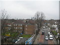
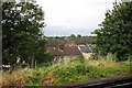
Evelina Road, Nunhead
Looking towards New Cross. This was taken from the railway bridge near Nunhead Station. The office buildings in the far distance, middle of shot, are at Canary Wharf.
Image: © Danny P Robinson
Taken: 11 Apr 2006
0.02 miles
2
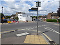
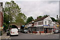
Junction of Hollydale, Ansdell and Evelina Roads
Image: © Shazz
Taken: 29 Jul 2016
0.03 miles
3
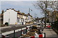
Evelina Road
Looking north-west across the junction with Hollydale Road.
Image: © Martin Addison
Taken: 16 Apr 2015
0.05 miles
4
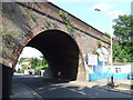
Railway arch near Nunhead station
Railway arch over Evelina Road, Nunhead.
Image: © Malc McDonald
Taken: 27 Jun 2010
0.06 miles
6
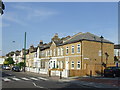
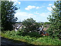
Evelina Road, Nunhead
Houses on Evelina Road at the junction with Hollydale Road.
Image: © Malc McDonald
Taken: 27 Jun 2010
0.07 miles
8
Nunhead
The junction of Evelina Road and Kimberley Avenue. The railway station lies to the right of this location.
Image: © Peter Trimming
Taken: 23 May 2023
0.09 miles
9
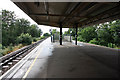
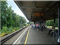
Nunhead station view
Nunhead station was opened on 18th September 1871, although the line through here had been opened on 1st August 1865 by the London, Chatham & Dover Railway when the original Crystal Palace & South London Junction Railway line from Brixton to Crystal Palace (High Level) began operation. The line was built to take passengers to the Crystal Palace exhibition site. The Nunhead to Greenwich Park line was opened in 1871 as far as Blackheath Hill on the same day as Nunhead station, with the final stretch to Greenwich Park coming into use in 1888. The Catford Loop line came into operation on 1st July 1892. It gave a second route out of London for the LCDR, and Nunhead thus became a three way junction. In 1925, the lines in the area were electrified, and a new station at Nunhead was built on the London side of the original site. In 1954 the line to Crystal Palace (High Level) was closed but the other lines still operate, although the line to Greenwich Park now runs only as far as Lewisham. Whilst waiting for a train, there are excellent views towards Central London and Docklands from the platforms at Nunhead. The view in this photograph takes in The Shard at London Bridge to the left, still under construction at this time.
Image: © Marathon
Taken: 24 Aug 2011
0.09 miles