IMAGES TAKEN NEAR TO
Consort Road, LONDON, SE15 2PJ
Introduction
This page details the photographs taken nearby to Consort Road, SE15 2PJ by members of the Geograph project.
The Geograph project started in 2005 with the aim of publishing, organising and preserving representative images for every square kilometre of Great Britain, Ireland and the Isle of Man.

There are currently over 7.5m images from over14,400 individuals and you can help contribute to the project by visiting https://www.geograph.org.uk
Image Map
Images are licensed for reuse under creativecommons.org/licenses/by-sa/2.0
Notes
- Clicking on the map will re-center to the selected point.
- The higher the marker number, the further away the image location is from the centre of the postcode.
Image Listing (97 Images Found)
Images are licensed for reuse under creativecommons.org/licenses/by-sa/2.0
Image
Details
Distance
1
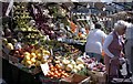
Fruit Stall - Choumert Road
Fruit stall in Choumert Road market area photographed c1990.
Image: © David Wright
Taken: Unknown
0.02 miles
2
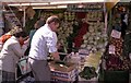
Choumert Road Market
Stall in Choumert Road market area photographed c1990
Image: © David Wright
Taken: Unknown
0.02 miles
3
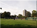
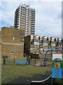
Cossall Park, Peckham Rye
This small play area and open-space is between Gordon Road and Woods Road.
In the background is a tower block on Clayton Road.
Image: © David Anstiss
Taken: 25 Sep 2011
0.08 miles
4
Hanover Park, SE15
At the junction of Clayton Road
Image: © Danny P Robinson
Taken: 19 Aug 2006
0.09 miles
5
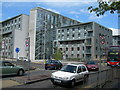
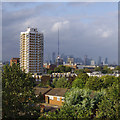
Clifton Estate, Peckham
Viewed from Clayton Road. The tower block is called Witcombe Point.
Image: © Danny P Robinson
Taken: 19 Aug 2006
0.09 miles
6
Witcombe Point, Peckham
Viewed from Frank's Café on the top level of a disused multi-storey car park.
The Isle of Dogs is in the background.
Image: © Ian Taylor
Taken: 10 Aug 2019
0.10 miles
7
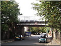
Railway bridge over Gordon Road
Gordon's Road leads from Brayards Road towards Consort Road.
The railway bridge leads between Peckham Rye to Nunhead.
Image: © David Anstiss
Taken: 25 Sep 2011
0.12 miles
8
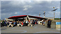
Frank's Caf?, Peckham
Open in the summer on the top level of a disused multi-storey car park.
This is the only occasion I've had a (plastic) glass of beer blown over by the wind.
Image: © Ian Taylor
Taken: 10 Aug 2019
0.13 miles
10
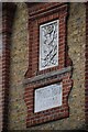
Woods Road School sign in brickwork
On the side of the building, now named John Donne Primary School.
Image: © David Martin
Taken: 15 May 2022
0.13 miles