IMAGES TAKEN NEAR TO
King Arthur Close, LONDON, SE15 2LP
Introduction
This page details the photographs taken nearby to King Arthur Close, SE15 2LP by members of the Geograph project.
The Geograph project started in 2005 with the aim of publishing, organising and preserving representative images for every square kilometre of Great Britain, Ireland and the Isle of Man.

There are currently over 7.5m images from over14,400 individuals and you can help contribute to the project by visiting https://www.geograph.org.uk
Image Map
Images are licensed for reuse under creativecommons.org/licenses/by-sa/2.0
Notes
- Clicking on the map will re-center to the selected point.
- The higher the marker number, the further away the image location is from the centre of the postcode.
Image Listing (95 Images Found)
Images are licensed for reuse under creativecommons.org/licenses/by-sa/2.0
Image
Details
Distance
1
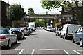
Peckham: Clifton Way
Looking west from the end of Loder Street. The overbridge carries the ex-LBSC South London line
Image: © Dr Neil Clifton
Taken: 18 Jun 2012
0.02 miles
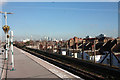
2
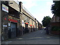
Station Passage, SE15
Railway arches north of Queen's Road Peckham station.
Image: © Malc McDonald
Taken: 27 Jun 2010
0.02 miles
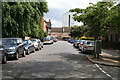
3
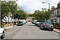
Peckham: Astbury Road
This road bends through a right-angle like an inverted letter L. This shows the view eastwards from the bend.
Image: © Dr Neil Clifton
Taken: 18 Jun 2012
0.06 miles
4
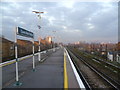
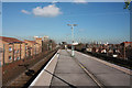
Queens Road Peckham station
Queens Road Peckham station opened with the rest of the line on 13th August 1866, and had two wooden side platforms and an intermediate centre platform to serve the third centre line. Until 1911 passenger trains ran to the East London Line stopping at Old Kent Road, and this link was re-instated on 9th December 2012 by London Overground. This photograph was taken during the first week of Overground operations.
The chimney to the right belongs to the South East London Combined Heat & Power Plant (SELCHP) which is a well-known feature on the lines into London Bridge. To the right of that is Canary Wharf and its surrounding towers.
Image: © Marathon
Taken: 12 Dec 2012
0.08 miles
6
Peckham: Clifton Way
Looking east from the end of Loder Street
Image: © Dr Neil Clifton
Taken: 18 Jun 2012
0.10 miles
9
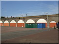
Railway arches in SE15
Railway arches and a sports pitch in Brimmington Park, Peckham.
Image: © Malc McDonald
Taken: 27 Jun 2010
0.11 miles
10
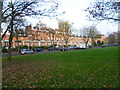
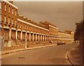
Clifton Terrace
Clifton Terrace, off Asylum Road, was built between 1846 and 1852. It was restored by Southwark Council in 1977 as the centrepiece of a redevelopment scheme.
Image: © Marathon
Taken: 16 Nov 2011
0.14 miles