IMAGES TAKEN NEAR TO
Pencraig Way, LONDON, SE15 1SH
Introduction
This page details the photographs taken nearby to Pencraig Way, SE15 1SH by members of the Geograph project.
The Geograph project started in 2005 with the aim of publishing, organising and preserving representative images for every square kilometre of Great Britain, Ireland and the Isle of Man.

There are currently over 7.5m images from over14,400 individuals and you can help contribute to the project by visiting https://www.geograph.org.uk
Image Map
Images are licensed for reuse under creativecommons.org/licenses/by-sa/2.0
Notes
- Clicking on the map will re-center to the selected point.
- The higher the marker number, the further away the image location is from the centre of the postcode.
Image Listing (114 Images Found)
Images are licensed for reuse under creativecommons.org/licenses/by-sa/2.0
Image
Details
Distance
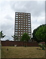
1
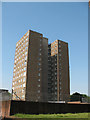
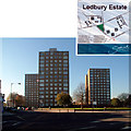
Sarnesfield House, Peckham
One of three H-shaped high-rise blocks forming part of the Ledbury Estate off the Old Kent Road.
Image: © Stephen Craven
Taken: 4 Jun 2010
0.03 miles
3
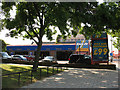
Kwik-Fit, Old Kent Road
Just to the west of Commercial Way on the south side of Old Kent Road.
Image: © Stephen Craven
Taken: 4 Jun 2010
0.04 miles
4
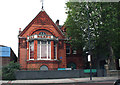
Old Kent Road: Former library
The lettering under the window is now not very clear but reads 'Camberwell Public Library No 1'
Image: © Dr Neil Clifton
Taken: 5 Jul 2012
0.05 miles
5
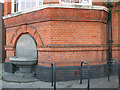
Former Camberwell Library (detail)
The building is that shown in Image - once a library, then a museum, currently disused. The detail is of a drinking fountain attached to the building, and an inscription in the brickwork above it: "Camberwell public library no.1 Anno Dom. 1890".
The building is listed grade 2 - listed building no. 471149 or Heritage asset number 1385739 as from 2011)
Image: © Stephen Craven
Taken: 4 Jun 2010
0.05 miles
6
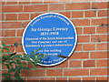
Blue plaque on the former Camberwell Library
The blue plaque on the grade 2 listed building is one erected by Southwark Council and reads "Sir George Livesey 1834-1908 Chairman of the South Metropolitan Gas Company and one of Southwark's greatest industrialists gave this building to the people".
For context see Image; for another detail see Image For the relics of Livesey's gasworks across the road, see Image
Image: © Stephen Craven
Taken: 4 Jun 2010
0.05 miles
10
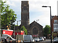
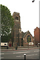
Tower of Christ Church, Camberwell
The church tower Image is a landmark along the Old Kent Road, but one has to go down a side street opposite to get a good view of it.
The church's name is properly that of Camberwell, Christ Church (named for the ancient parish from which its own was taken) but it markets itself as a Peckham church (being the nearer urban centre).
The church is in the Gothic revival style, and was built in 1867 to the designs of architect E. Bassett Keeling. The church was damaged by bombing during the Second World War and was repaired and remodelled in 1958. The dangerous top of the tower was removed in the late 1960s and a new flat roof with parapet walls was provided (information from Southwark diocesan website).
Image: © Stephen Craven
Taken: 22 Jul 2015
0.06 miles