IMAGES TAKEN NEAR TO
Lovelinch Close, LONDON, SE15 1EU
Introduction
This page details the photographs taken nearby to Lovelinch Close, SE15 1EU by members of the Geograph project.
The Geograph project started in 2005 with the aim of publishing, organising and preserving representative images for every square kilometre of Great Britain, Ireland and the Isle of Man.

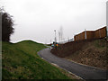
There are currently over 7.5m images from over14,400 individuals and you can help contribute to the project by visiting https://www.geograph.org.uk
Image Map
Images are licensed for reuse under creativecommons.org/licenses/by-sa/2.0
Notes
- Clicking on the map will re-center to the selected point.
- The higher the marker number, the further away the image location is from the centre of the postcode.
Image Listing (173 Images Found)
Images are licensed for reuse under creativecommons.org/licenses/by-sa/2.0
Image
Details
Distance
1
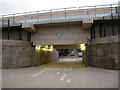
Rollins Street subway
A new subway under the railway embankment links Rollins Street to the west with Bridge House Meadows to the east.
Image: © Stephen Craven
Taken: 18 Jan 2013
0.03 miles
2
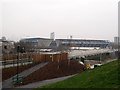
London Overground new line and The Den
In the foreground, a new path leads down to Surrey Canal Road. Behind that, the new London Overground line, and in the background is the Den (Millwall football ground). In the far distance to the left, you can just make out the towers of the City in the mist.
Image: © Stephen Craven
Taken: 18 Jan 2013
0.03 miles
3
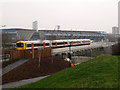
Train passing the site of a future new station
A class 378 train heads northwards on the new London Overground line just south of Surrey Canal Road. This is the site identified for a potential new station. The money was not found for it in the railway reopening scheme, but the design and construction of the embankment, and the signalling, was undertaken with the possibility in mind. If potential housing developments on brownfield sites around Surrey Canal Road ever happen, there will be a better argument for the station. The pedestrian subway Image would form part of the station.
In this view, workmen are erecting lighting columns for the adjacent path.
Image: © Stephen Craven
Taken: 18 Jan 2013
0.03 miles
4
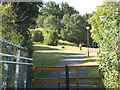
Bridge House Meadows
Despite the bucolic name, the 'meadows' is in fact a narrow strip of greenery between two industrial areas. This is the northern end, viewed from the footbridge over Surrey Canal Road (demolished in May 2011 to make way for a reinstated railway line).
Image: © Stephen Craven
Taken: 22 May 2009
0.04 miles
5
New path through Bridge House Meadows (2)
The path rises up from Surrey Canal Road towards the level of the new railway line (right). Contractors are finishing off the landscaping.
Image: © Stephen Craven
Taken: 18 Jan 2013
0.04 miles
6

Bridgehouse Meadows, SE14
Bridgehouse Meadows occupies the site of the former New Cross greyhound and speedway stadium, south of Surrey Canal Road.
Image: © Malc McDonald
Taken: 10 Oct 2010
0.06 miles
7
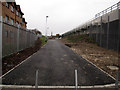
New path through Bridge House Meadows (1)
The southern end of the path, with a couple of bollards to prevent vehicle access.
Image: © Stephen Craven
Taken: 18 Jan 2013
0.06 miles
8
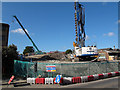
Surrey Canal Road new railway bridge: abutment
This view shows the augur boring rig at work on the southern side of the road - its full height can be seen in Image Behind it the railway embankment is being built up, on what used to be Bridge House Meadows Image
Image: © Stephen Craven
Taken: 22 Jul 2011
0.07 miles
9
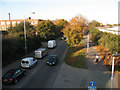
Surrey Canal Road, westbound in the rush hour
The road, as its name suggests, follows the line of a former canal. It is always slow-moving westbound in the morning rush-hour, sometimes completely gridlocked. The former towpath is a shared-use pedestrian/cycle path, part of the London Cycle Network.
Image: © Stephen Craven
Taken: 22 Oct 2008
0.08 miles
10
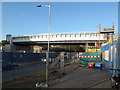
New London Overground bridge
This bridge over Surrey Canal Road was put in place over the weekend of 8/9 October 2011 to replace the previous footbridge Image Construction of the abutments either side continued for several weeks afterwards. The bridge was not scheduled to carry trains (on the London Overground route to Clapham Junction) for another year or so.
Image: © Stephen Craven
Taken: 19 Oct 2011
0.08 miles