IMAGES TAKEN NEAR TO
Fenham Road, LONDON, SE15 1AE
Introduction
This page details the photographs taken nearby to Fenham Road, SE15 1AE by members of the Geograph project.
The Geograph project started in 2005 with the aim of publishing, organising and preserving representative images for every square kilometre of Great Britain, Ireland and the Isle of Man.

There are currently over 7.5m images from over14,400 individuals and you can help contribute to the project by visiting https://www.geograph.org.uk
Image Map
Images are licensed for reuse under creativecommons.org/licenses/by-sa/2.0
Notes
- Clicking on the map will re-center to the selected point.
- The higher the marker number, the further away the image location is from the centre of the postcode.
Image Listing (69 Images Found)
Images are licensed for reuse under creativecommons.org/licenses/by-sa/2.0
Image
Details
Distance
1
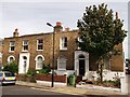
121/123 Friary Road, Peckham
Two Grade II listed houses on the road. Part of a long set of listed houses on the road.
See http://www.britishlistedbuildings.co.uk/en-470939-121-and-123-camberwell for more details on the buildings.
Image: © David Anstiss
Taken: 25 Sep 2011
0.06 miles
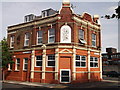
2
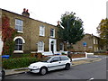
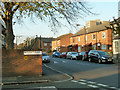
House at corner of Friary and Fenham Roads Peckham
Image: © PAUL FARMER
Taken: 21 Oct 2012
0.06 miles
3
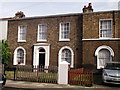
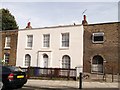
133 Friary Road, Peckham
Part of a terrace (127-151) of Grade II listed houses on the westside of the road.
See http://www.britishlistedbuildings.co.uk/en-470940-127-151-camberwell for more details about the building.
Image: © David Anstiss
Taken: 25 Sep 2011
0.08 miles
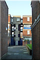
4

Hoyland Close, 8 - 23
Actually on Naylor Road, but accessed from behind by what is presumably Hoyland Close, along with other flats on the block.
Image: © Robin Webster
Taken: 19 Nov 2011
0.09 miles
6
Naylor Road, SE15
Older houses just showing on the right, then a zone of newer housing, largely replacing streets of older housing. However, these nearest houses could well be on a bomb site, as the old houses here had gone by 1952 leaving a gap.
Image: © Robin Webster
Taken: 19 Nov 2011
0.11 miles
7
Caroline Gardens (Licensed Victualler?s Asylum) Asylum Rd Peckham
Towards the New Cross end of the Old Kent Road is Asylum Road named for a large complex, a building built in the classical style. This building used to house the Licensed Victualler’s Asylum. I have often wondered what the criteria were for admittance. Anyone want to post a polite suggestion? Please do :-)
More stories of asylums and other stuff related to them in the Branch Magazine of the Central London Branch on their website www.cwucentrallondon.org.uk May 2004 issue
Image: © Cockney Laurie
Taken: Unknown
0.11 miles
8
157 Friary Road, Peckham
Grade II listed house. Part of a group, 153, 155 and 157 are all listed.
Image: © David Anstiss
Taken: 25 Sep 2011
0.11 miles
9
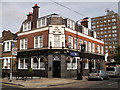
Duke of Sussex, Public House, Peckham
Pub on the junction on Friary Road (on the left) and Commercial Road (on the right).
Image: © David Anstiss
Taken: 25 Sep 2011
0.12 miles
10
The Beehive, Peckham
Former Public house on the junction of Pennethorne Road (on the left) and Goldsmith Road (on the right). Meeting House Lane is in the background.
Been converted into flats.
Image: © David Anstiss
Taken: 25 Sep 2011
0.12 miles