IMAGES TAKEN NEAR TO
Fenham Road, LONDON, SE15 1AB
Introduction
This page details the photographs taken nearby to Fenham Road, SE15 1AB by members of the Geograph project.
The Geograph project started in 2005 with the aim of publishing, organising and preserving representative images for every square kilometre of Great Britain, Ireland and the Isle of Man.

There are currently over 7.5m images from over14,400 individuals and you can help contribute to the project by visiting https://www.geograph.org.uk
Image Map
Images are licensed for reuse under creativecommons.org/licenses/by-sa/2.0
Notes
- Clicking on the map will re-center to the selected point.
- The higher the marker number, the further away the image location is from the centre of the postcode.
Image Listing (51 Images Found)
Images are licensed for reuse under creativecommons.org/licenses/by-sa/2.0
Image
Details
Distance
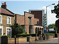
1
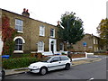
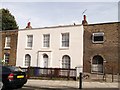
House at corner of Friary and Fenham Roads Peckham
Image: © PAUL FARMER
Taken: 21 Oct 2012
0.05 miles
2
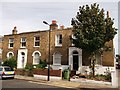
121/123 Friary Road, Peckham
Two Grade II listed houses on the road. Part of a long set of listed houses on the road.
See http://www.britishlistedbuildings.co.uk/en-470939-121-and-123-camberwell for more details on the buildings.
Image: © David Anstiss
Taken: 25 Sep 2011
0.05 miles
3
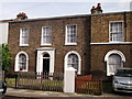
133 Friary Road, Peckham
Part of a terrace (127-151) of Grade II listed houses on the westside of the road.
See http://www.britishlistedbuildings.co.uk/en-470940-127-151-camberwell for more details about the building.
Image: © David Anstiss
Taken: 25 Sep 2011
0.06 miles
4
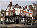
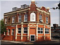
Duke of Sussex, Public House, Peckham
Pub on the junction on Friary Road (on the left) and Commercial Road (on the right).
Image: © David Anstiss
Taken: 25 Sep 2011
0.09 miles
5
157 Friary Road, Peckham
Grade II listed house. Part of a group, 153, 155 and 157 are all listed.
Image: © David Anstiss
Taken: 25 Sep 2011
0.11 miles
6
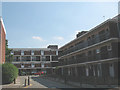
Lympstone Gardens, Peckham
Low-rise housing off Bird in Bush Road.
Image: © Stephen Craven
Taken: 4 Jun 2010
0.13 miles
7
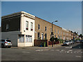
Friary Road, Peckham
Looking south along Friary Road from its junction with Bird-in-Bush Road. The angled corner of no. 55 suggests that it may have been a corner shop originally.
For the buildings that gave the road its name see Image looking in the opposite direction from the same junction.
Image: © Stephen Craven
Taken: 4 Jun 2010
0.15 miles
8
The Beehive, Peckham
Former Public house on the junction of Pennethorne Road (on the left) and Goldsmith Road (on the right). Meeting House Lane is in the background.
Been converted into flats.
Image: © David Anstiss
Taken: 25 Sep 2011
0.15 miles
9

Ledbury Street, Camberwell
I stopped on impulse here on seeing the name of the block in the foreground, Credenhill House, because of its link with my family history Image
Image: © Stephen Craven
Taken: 3 Jul 2014
0.16 miles
10
Peckham Park Road Baptist Chapel
A church was built on this site in 1861/2. The plinth and foundation stone were originally part of Old Westminster Bridge, and can still be seen although the chapel was partly rebuilt in 1951 after war damage. Source: http://www.peckhamhistory.org.uk/churchesBap.htm
Image: © Stephen Craven
Taken: 4 Jun 2010
0.16 miles