IMAGES TAKEN NEAR TO
Merrick Square, LONDON, SE1 4JB
Introduction
This page details the photographs taken nearby to Merrick Square, SE1 4JB by members of the Geograph project.
The Geograph project started in 2005 with the aim of publishing, organising and preserving representative images for every square kilometre of Great Britain, Ireland and the Isle of Man.

There are currently over 7.5m images from over14,400 individuals and you can help contribute to the project by visiting https://www.geograph.org.uk
Image Map
Images are licensed for reuse under creativecommons.org/licenses/by-sa/2.0
Notes
- Clicking on the map will re-center to the selected point.
- The higher the marker number, the further away the image location is from the centre of the postcode.
Image Listing (416 Images Found)
Images are licensed for reuse under creativecommons.org/licenses/by-sa/2.0
Image
Details
Distance
1
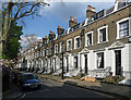
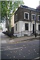
1-12 Merrick Square
The early-mid C19th developments in Trinity Church Square and surrounding streets are very well preserved. The terraces are handsome and uniform, in brick with stuccoed and rusticated ground floors and stuccoed window surrounds. The houses are generally of three storeys plus basements and two bays wide. This square, dating from c1853, is very much the junior square, a storey shorter and less satisfyingly proportioned. Grade II listed.
Image: © Stephen Richards
Taken: 6 May 2013
0.00 miles
2
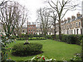
Merrick Square, off Trinity Street (1)
This photo shows the private gardens in the centre of the square. See also Image
Image: © Stephen Craven
Taken: 20 Mar 2010
0.02 miles
3
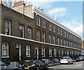
4-22 Falmouth Road
The early-mid C19th developments in Trinity Church Square and surrounding streets are very well preserved. The terraces are handsome and uniform, in brick with stuccoed and rusticated ground floors and stuccoed window surrounds. The houses are generally of three storeys plus basements and two bays wide. This later, stucco-less development of c1835 is plainer but dignified and has some simple brick detail. Grade II listed.
Image: © Stephen Richards
Taken: 6 May 2013
0.02 miles
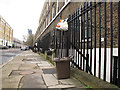
4
Merrick Square, Newington, Southwark
Said to be one of London's few squares to retain the original iron railings.
Image: © Brian Whittle
Taken: 30 Nov 2017
0.02 miles
6
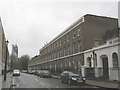
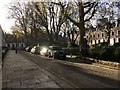
Falmouth Road, Southwark
Looking south from the northern end of Falmouth Road at its junction with Trinity Street, showing the 19th century terraced housing on the west side - compare Image In the distance is the recently completed Strata Tower. The building at the right of the photo is the Surrey Dispensary: see Image
Image: © Stephen Craven
Taken: 20 Mar 2010
0.03 miles
7
Terrace, Trinity Street SE1
The terrace, of seven properties, its end bays slightly projecting forward, dates from 1827-1832 http://www.britishlistedbuildings.co.uk/en-471423-numbers-25-47-and-attached-railings-25-4 .
Image: © Derek Harper
Taken: 1 Feb 2011
0.03 miles
8
Waste bins on Falmouth Road
These are rather small waste bins. I presume that being grey they are for the "remainder" waste that is neither compostable nor recyclable.
Image: © Stephen Craven
Taken: 1 Feb 2013
0.03 miles
9
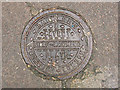
Coal-hole cover
A cast iron cover to a coal hole outside a terrace of houses in Falmouth Road, Southwark. For context see Image
The wording on the cover reads: "Hayward's - Borough - London - D Patent self-locking plate". Hayward Brothers were based in nearby Union Street.
Image: © Stephen Craven
Taken: 20 Mar 2010
0.03 miles
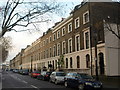
10
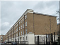
Alderney Mews, London SE1
Impressive terrace of houses in Falmouth Road.
Image: © Christine Matthews
Taken: 8 Mar 2015
0.03 miles