IMAGES TAKEN NEAR TO
Trinity Church Square, LONDON, SE1 4HY
Introduction
This page details the photographs taken nearby to Trinity Church Square, SE1 4HY by members of the Geograph project.
The Geograph project started in 2005 with the aim of publishing, organising and preserving representative images for every square kilometre of Great Britain, Ireland and the Isle of Man.

There are currently over 7.5m images from over14,400 individuals and you can help contribute to the project by visiting https://www.geograph.org.uk
Image Map
Images are licensed for reuse under creativecommons.org/licenses/by-sa/2.0
Notes
- Clicking on the map will re-center to the selected point.
- The higher the marker number, the further away the image location is from the centre of the postcode.
Image Listing (451 Images Found)
Images are licensed for reuse under creativecommons.org/licenses/by-sa/2.0
Image
Details
Distance
1
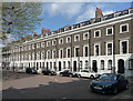
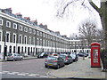
31-44 Trinity Church Square
The early-mid C19th developments in Trinity Church Square and surrounding streets are very well preserved. The terraces are handsome and uniform, in brick with stuccoed and rusticated ground floors and stuccoed window surrounds. The houses are generally of three storeys plus basements and two bays wide. These, which form the east side of the square, were built c1827. Grade II listed.
Image: © Stephen Richards
Taken: 6 May 2013
0.00 miles
2
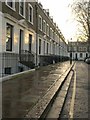
Trinity Church Square
The eastern side of the square, seen from Trinity Street.
Image: © Derek Harper
Taken: 1 Feb 2011
0.01 miles
3
Trinity Church Square, Newington, Southwark
Image: © Brian Whittle
Taken: 30 Nov 2017
0.02 miles
4
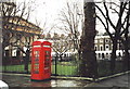
Telephone box, Trinity Church Square, Southwark
Image: © nick macneill
Taken: 4 Jan 2002
0.02 miles
5
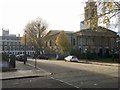
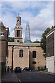
The Henry Wood Hall (former Holy Trinity Church)
Image: © John Salmon
Taken: 16 Oct 2010
0.02 miles
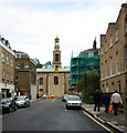
6
The Henry Wood Hall (former Holy Trinity Church)
Image: © John Salmon
Taken: 16 Oct 2010
0.02 miles
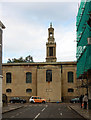
7
The Henry Wood Hall (former Holy Trinity Church)
Image: © John Salmon
Taken: 16 Oct 2010
0.02 miles
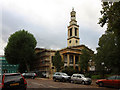
8
The Henry Wood Hall (former Holy Trinity Church)
Image: © John Salmon
Taken: 16 Oct 2010
0.02 miles
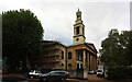
9
Which one is taller?
Trinity Church and The Shard.
Image: © Fernweh
Taken: 11 Aug 2014
0.02 miles
10
Trinity Church Square, SE1
Trinity Church Square was developed in the 1820s. It takes its name from Trinity House, the authority responsible for lighthouses in England, Wales, the Channel Islands and Gibraltar. Trinity House developed the square and still owns the freehold to most of the properties.
The square is a Conservation Area, and most of the buildings are Grade II listed.
Image: © Malc McDonald
Taken: 9 Feb 2011
0.02 miles