IMAGES TAKEN NEAR TO
Harold Estate, Pages Walk, LONDON, SE1 4HW
Introduction
This page details the photographs taken nearby to Harold Estate, Pages Walk, SE1 4HW by members of the Geograph project.
The Geograph project started in 2005 with the aim of publishing, organising and preserving representative images for every square kilometre of Great Britain, Ireland and the Isle of Man.

There are currently over 7.5m images from over14,400 individuals and you can help contribute to the project by visiting https://www.geograph.org.uk
Image Map
Images are licensed for reuse under creativecommons.org/licenses/by-sa/2.0
Notes
- Clicking on the map will re-center to the selected point.
- The higher the marker number, the further away the image location is from the centre of the postcode.
Image Listing (234 Images Found)
Images are licensed for reuse under creativecommons.org/licenses/by-sa/2.0
Image
Details
Distance
1
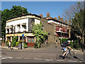
The Victoria
A pub on the corner of Page's Walk and Willow Walk. It still proclaims the name of the original owning brewery (Truman Hanbury Buxton). Getting the "Burton Ales" to the pub would not have been difficult as it stood opposite a large railway goods yard Image
Image: © Stephen Craven
Taken: 25 May 2012
0.03 miles
2
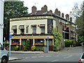
The Victoria, SE1
At the junction of Page's Walk and Willow Walk.
Image: © Robin Webster
Taken: 23 Jul 2011
0.03 miles
3
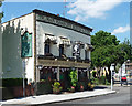
The Victoria, Pages Walk
Nice little former Truman Hanbury Buxton pub.
Image: © Stephen Richards
Taken: 27 May 2013
0.03 miles
4

OBC mural, Webb Street
A mural on the brick wall of the car park of the adjacent youth club Image It depicts contemporary London landmarks around a figure presumably representing the club's founder John Stansfeld.
Image: © Stephen Craven
Taken: 11 May 2012
0.03 miles
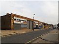
5
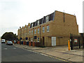
New houses on Pages Walk
A short terrace of town houses, built in 2013 and being marketed by Felicity J Lord estate agents. There were previously light industrial units (mainly vehicle repair) on the site.
Image: © Stephen Craven
Taken: 16 Jul 2013
0.04 miles
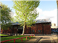
6
Next for the chop?
Most of these light industrial units on the east side of Pages Walk, part of the "Rich Industrial Estate", were already closed and "for sale" by summer 2013. I expect that they would be demolished and replaced by houses as has already happened across the road Image, as Bermondsey becomes ever more “gentrified”.
Image: © Stephen Craven
Taken: 16 Jul 2013
0.04 miles
7
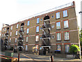
Arundel Buildings, Webb Street
Social housing run by a co-operative. http://www.housingnet.co.uk/housingnet-html/Arundel_Buildings_Housing_Co_Operative_.html
Image: © Stephen Craven
Taken: 11 May 2012
0.05 miles
8
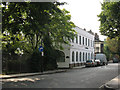
Willow Walk
Willow Walk runs along the north side of the former Bricklayers Arms railway goods yard. The white building on the corner, now called The Willows, was probably railway offices originally but now hosts several small business.
Image: © Stephen Craven
Taken: 2 Jun 2011
0.05 miles
9
Stansfeld Oxford & Bermondsey Club
A building on Webb Street, Bermondsey. Founded by John Stansfeld (later Vicar of the nearby church of St Anne Image) as a boys' club, as part of the late 19th Century "Settlement Movement". The present building still functions as a youth club, presumably no longer exclusively for boys. History at http://www.infed.org/features/oxford_in_bermondsey.htm
Image: © Stephen Craven
Taken: 11 May 2012
0.05 miles
10
Crimscott Street
A road lined with small industrial and business units, off Grange Road, Bermondsey. It is one-way southbound towards Willow Walk, hence the arrow painted on the road.
Image: © Stephen Craven
Taken: 2 Jun 2011
0.06 miles