IMAGES TAKEN NEAR TO
Guinness Square, Pages Walk, LONDON, SE1 4HP
Introduction
This page details the photographs taken nearby to Guinness Square, Pages Walk, SE1 4HP by members of the Geograph project.
The Geograph project started in 2005 with the aim of publishing, organising and preserving representative images for every square kilometre of Great Britain, Ireland and the Isle of Man.

There are currently over 7.5m images from over14,400 individuals and you can help contribute to the project by visiting https://www.geograph.org.uk
Image Map
Images are licensed for reuse under creativecommons.org/licenses/by-sa/2.0
Notes
- Clicking on the map will re-center to the selected point.
- The higher the marker number, the further away the image location is from the centre of the postcode.
Image Listing (184 Images Found)
Images are licensed for reuse under creativecommons.org/licenses/by-sa/2.0
Image
Details
Distance
1
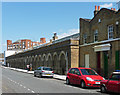
Former stables, Pages Walk
Mid C19th, and no doubt associated with the Bricklayers Arms Station which once stood hereabouts.
Now converted to business units.
Image: © Stephen Richards
Taken: 27 May 2013
0.03 miles
2
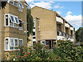
Guinness Square, Bermondsey
The housing development is owned by the Guinness Trust, hence the name.
Image: © Stephen Craven
Taken: 18 Jul 2009
0.03 miles
3
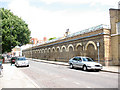
Old railway buildings, Pages Walk, Bermondsey
The road marked the western end of the Bricklayers Arms railway depot. This range of industrial brick buildings is presumably part of that heritage.
Image: © Stephen Craven
Taken: 18 Jul 2009
0.04 miles
4
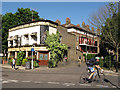
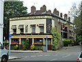
The Victoria
A pub on the corner of Page's Walk and Willow Walk. It still proclaims the name of the original owning brewery (Truman Hanbury Buxton). Getting the "Burton Ales" to the pub would not have been difficult as it stood opposite a large railway goods yard Image
Image: © Stephen Craven
Taken: 25 May 2012
0.04 miles
5
The Victoria, SE1
At the junction of Page's Walk and Willow Walk.
Image: © Robin Webster
Taken: 23 Jul 2011
0.04 miles
6
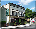
The Victoria, Pages Walk
Nice little former Truman Hanbury Buxton pub.
Image: © Stephen Richards
Taken: 27 May 2013
0.04 miles
7
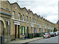
Terraced housing, Page's Walk SE1
Formerly backing on to the Bricklayers Arms station and locomotive depot, these were built for the railwaymen. Bricklayers Arms was originally a passenger terminus, built as a consequence of inter-company bickering about the use of London Bridge station. This lasted only a few years, after which it was a freight only station, but a very important one.
Image: © Robin Webster
Taken: 23 Jul 2011
0.05 miles
8
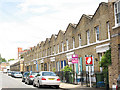
Terraced houses in Pages Walk, Bermondsey
The houses are probably of the same age as the railway buildings beyond them Image The roof arrangement, with each house having a gable end and a valley gutter between adjacent houses, is unusual and may be influenced by the form of industrial buildings.
Image: © Stephen Craven
Taken: 18 Jul 2009
0.05 miles
9
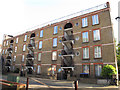
Arundel Buildings, Webb Street
Social housing run by a co-operative. http://www.housingnet.co.uk/housingnet-html/Arundel_Buildings_Housing_Co_Operative_.html
Image: © Stephen Craven
Taken: 11 May 2012
0.05 miles
10
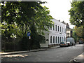
Willow Walk
Willow Walk runs along the north side of the former Bricklayers Arms railway goods yard. The white building on the corner, now called The Willows, was probably railway offices originally but now hosts several small business.
Image: © Stephen Craven
Taken: 2 Jun 2011
0.06 miles