IMAGES TAKEN NEAR TO
New Kent Road, LONDON, SE1 4AN
Introduction
This page details the photographs taken nearby to New Kent Road, SE1 4AN by members of the Geograph project.
The Geograph project started in 2005 with the aim of publishing, organising and preserving representative images for every square kilometre of Great Britain, Ireland and the Isle of Man.

There are currently over 7.5m images from over14,400 individuals and you can help contribute to the project by visiting https://www.geograph.org.uk
Image Map
Images are licensed for reuse under creativecommons.org/licenses/by-sa/2.0
Notes
- Clicking on the map will re-center to the selected point.
- The higher the marker number, the further away the image location is from the centre of the postcode.
Image Listing (171 Images Found)
Images are licensed for reuse under creativecommons.org/licenses/by-sa/2.0
Image
Details
Distance
1
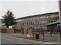
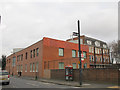
St Saviour's & St Olave's school (5)
Bartholomew Street entrance.
Image: © Stephen Craven
Taken: 8 Mar 2015
0.02 miles
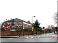
2
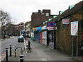
St Saviour's & St Olave's school (2)
This is the southern end of the site at the corner of New Kent Road and Bartholomew Street. See also Image
Image: © Stephen Craven
Taken: 20 Mar 2010
0.02 miles
3
St Saviour's & St Olave's school (1)
This is the northern end of the site photographed from the other side of Great Dover Street.
Image: © Stephen Craven
Taken: 20 Mar 2010
0.02 miles
4
St Saviour's & St Olave's school (4)
The north end of a modern block of the school.
Image: © Stephen Craven
Taken: 8 Mar 2015
0.02 miles
5
St Saviour's & St Olave's school (3)
The south end of a modern block of the school.
Image: © Stephen Craven
Taken: 8 Mar 2015
0.03 miles
7
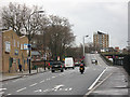
Bricklayers Arms flyover (1)
Looking east along the New Kent Road (eastbound carriageway) to the flyover onto the Old Kent Road. See also Image
Image: © Stephen Craven
Taken: 20 Mar 2010
0.04 miles
8
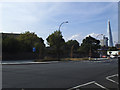
Bricklayers Arms: site of subway
Where the flower bed is now, used to be the ramp down to a subway. It was removed in 2013. I don't have a photo of the former subway at this side, but Image shown the one at the north-east corner of the roundabout.
Image: © Stephen Craven
Taken: 17 Jul 2014
0.04 miles
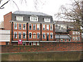
10
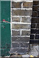
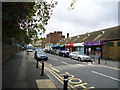
Benchmark on The Beehive pub, Bartholomew Street
Ordnance Survey cut mark benchmark described on the Bench Mark Database at http://www.bench-marks.org.uk/bm37853
Image: © Roger Templeman
Taken: 6 May 2011
0.05 miles