IMAGES TAKEN NEAR TO
Heald Street, LONDON, SE14 6TX
Introduction
This page details the photographs taken nearby to Heald Street, SE14 6TX by members of the Geograph project.
The Geograph project started in 2005 with the aim of publishing, organising and preserving representative images for every square kilometre of Great Britain, Ireland and the Isle of Man.

There are currently over 7.5m images from over14,400 individuals and you can help contribute to the project by visiting https://www.geograph.org.uk
Image Map
Images are licensed for reuse under creativecommons.org/licenses/by-sa/2.0
Notes
- Clicking on the map will re-center to the selected point.
- The higher the marker number, the further away the image location is from the centre of the postcode.
Image Listing (137 Images Found)
Images are licensed for reuse under creativecommons.org/licenses/by-sa/2.0
Image
Details
Distance
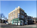
1
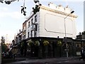
Royal Albert Public House, Deptford
This pub is on the junction of A2 New Cross Road (on the left) and Florence Road (on the right).
Image: © David Anstiss
Taken: 25 Sep 2011
0.06 miles
2
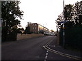
Florence Road bridge
This road leads from the A2 New Cross Road towards the A20 Lewisham Way.
It passes over the railway between St.Johns and New Cross.
Image: © David Anstiss
Taken: 25 Sep 2011
0.08 miles
3
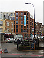
New Cross Road, New Cross
Looking towards Deptford from the junction with Florence Road on a dismal Saturday afternoon. The Royal Albert pub is just out of view on the right but the blackboard advertises its 'new cosy extension'.
Image: © Stephen McKay
Taken: 1 Dec 2018
0.08 miles
4
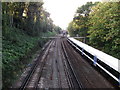
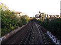
Railway to New Cross
As seen from Image
This line leads from Lewisham (via St Johns) towards New Cross (and onward to central London).
The train on the right heads towards St Johns.
In the background is the A2 New Cross road bridge.
Image: © David Anstiss
Taken: 25 Sep 2011
0.08 miles
5

Pitman House, Deptford
Large housing block between Tanner's Hill and Heston Street.
Image: © David Anstiss
Taken: 25 Sep 2011
0.08 miles
6
Railway to St.Johns
As seen from Image
This line leads from central London (via New Cross) towards St.Johns and Lewisham.
In the background is Tanners Road Bridge.
Image: © David Anstiss
Taken: 25 Sep 2011
0.08 miles
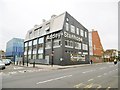
7
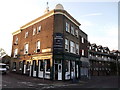
Royal Standard Public House, Deptford
Pub on the junction of Heald Street (on the left) and Tanner's Hill (on the right).
Image: © David Anstiss
Taken: 25 Sep 2011
0.09 miles
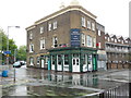
9
Royal Standard, Deptford
Public house now used as a hostel.
Image: © Chris Whippet
Taken: 16 Feb 2014
0.09 miles
10
Deptford, Addey & Stanhope School
Specialist technology school on New Cross Road: http://www.as.lewisham.sch.uk/
Image: © Mike Faherty
Taken: 28 Mar 2015
0.09 miles