IMAGES TAKEN NEAR TO
Shardeloes Road, LONDON, SE14 6RS
Introduction
This page details the photographs taken nearby to Shardeloes Road, SE14 6RS by members of the Geograph project.
The Geograph project started in 2005 with the aim of publishing, organising and preserving representative images for every square kilometre of Great Britain, Ireland and the Isle of Man.

There are currently over 7.5m images from over14,400 individuals and you can help contribute to the project by visiting https://www.geograph.org.uk
Image Map
Images are licensed for reuse under creativecommons.org/licenses/by-sa/2.0
Notes
- Clicking on the map will re-center to the selected point.
- The higher the marker number, the further away the image location is from the centre of the postcode.
Image Listing (6 Images Found)
Images are licensed for reuse under creativecommons.org/licenses/by-sa/2.0
Image
Details
Distance
1
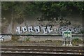
Graffiti, trackside, south of New Cross Gate
Image: © Christopher Hilton
Taken: 22 Oct 2009
0.19 miles
3
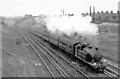
London Bridge - Tunbridge Wells West train at Brockley, 1948
View towards New Cross Gate and London from the Endwell Road bridge, climbing up the steep climb from New Cross Gate is the 18.30 from London Bridge, still in those days headed by an ex-LB&SCR Marsh class I3 4-4-2T, No. S2025 (later to be 32025), built as No. 25 in 3/1909, becoming No. 2025 after Grouping and surviving only until 1/50. [Not a good photograph and probably in the rain, but a 'Scene from the Distant Past'].
Image: © Ben Brooksbank
Taken: 21 Jul 1948
0.24 miles
4
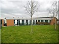
Nunhead, college
Christ the King: Aquinas Sixth Form College, seen from Wallbutton Road. http://www.ctksfc.ac.uk/site/aquinas/
Image: © Mike Faherty
Taken: 28 Mar 2015
0.24 miles