IMAGES TAKEN NEAR TO
Nynehead Street, LONDON, SE14 6JB
Introduction
This page details the photographs taken nearby to Nynehead Street, SE14 6JB by members of the Geograph project.
The Geograph project started in 2005 with the aim of publishing, organising and preserving representative images for every square kilometre of Great Britain, Ireland and the Isle of Man.

There are currently over 7.5m images from over14,400 individuals and you can help contribute to the project by visiting https://www.geograph.org.uk
Image Map
Images are licensed for reuse under creativecommons.org/licenses/by-sa/2.0
Notes
- Clicking on the map will re-center to the selected point.
- The higher the marker number, the further away the image location is from the centre of the postcode.
Image Listing (121 Images Found)
Images are licensed for reuse under creativecommons.org/licenses/by-sa/2.0
Image
Details
Distance
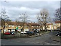
1
New Testament church, Bawtree Road, Deptford
The building looks as if was originally a school rather than a church, and from its architectural style certainly pre-dates the housing all around it.
Image: © Stephen Craven
Taken: 1 Jun 2009
0.05 miles
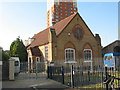
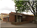
2
New Testament Church of God, Deptford
The church has been extended to the east of the original building Image since a previous photo was taken in 2009 showing the small hall originally occupying the site Image
Image: © Stephen Craven
Taken: 19 Apr 2014
0.05 miles
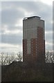
4
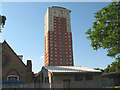
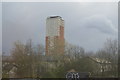
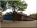
Hawke Tower, Deptford
The single high-rise block (23 storeys) in an otherwise low-rise estate, Hawke Tower is a landmark in the area. It appears for instance in Image and other Geographs of the area. It was refurbished in the 1990s.
In the foreground is the New Testament Church of God, with its hall (right) which has since been rebuilt as an extension of the church - see Image
Image: © Stephen Craven
Taken: 1 Jun 2009
0.06 miles
5
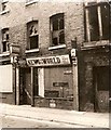
The end of the News - all human life was there
The news of the closure of the News of the World reminded me wistfully of this picture of a boarded-up shop awaiting demolition, taken for a college project back in 1969. It was, I recall in Amersham Vale though after 42 years I cannot be absolutely sure of its precise location. An innocent age long before 'phone hacking!
Image: © Chris Denny
Taken: Unknown
0.07 miles
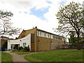
8
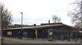
Woodpecker Centre, Deptford (closed)
A former community centre at the heart of a housing estate, built c.1977. See http://www.deptfordptrs.com/pdf/deptford-rejuvenation-article.pdf for a 1977 article in "Building Design" about the estate.
Image: © Stephen Craven
Taken: 19 Apr 2014
0.08 miles
9
The former Spanish Steps pub, Deptford
This pub was part of the Woodpecker Centre at the heart of a housing estate, built c.1977. See http://www.deptfordptrs.com/pdf/deptford-rejuvenation-article.pdf for a 1977 article in "Building Design" about the estate. It has been closed since at least 2007 as far as I know. only the Courage logo and an empty inn sign frame hint at its former use.
Image: © Stephen Craven
Taken: 19 Apr 2014
0.09 miles