IMAGES TAKEN NEAR TO
Desmond Street, LONDON, SE14 6JA
Introduction
This page details the photographs taken nearby to Desmond Street, SE14 6JA by members of the Geograph project.
The Geograph project started in 2005 with the aim of publishing, organising and preserving representative images for every square kilometre of Great Britain, Ireland and the Isle of Man.

There are currently over 7.5m images from over14,400 individuals and you can help contribute to the project by visiting https://www.geograph.org.uk
Image Map
Images are licensed for reuse under creativecommons.org/licenses/by-sa/2.0
Notes
- Clicking on the map will re-center to the selected point.
- The higher the marker number, the further away the image location is from the centre of the postcode.
Image Listing (142 Images Found)
Images are licensed for reuse under creativecommons.org/licenses/by-sa/2.0
Image
Details
Distance
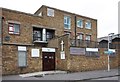
1
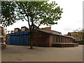
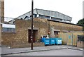
Woodpecker Centre, Deptford (closed)
A former community centre at the heart of a housing estate, built c.1977. See http://www.deptfordptrs.com/pdf/deptford-rejuvenation-article.pdf for a 1977 article in "Building Design" about the estate.
Image: © Stephen Craven
Taken: 19 Apr 2014
0.06 miles
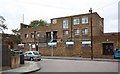
3
New Testament Church of God, Deptford
The church has been extended to the east of the original building Image since a previous photo was taken in 2009 showing the small hall originally occupying the site Image
Image: © Stephen Craven
Taken: 19 Apr 2014
0.07 miles
4
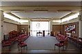
St Michael, Desmond Street, Hatcham - Interior
Image: © John Salmon
Taken: 8 Oct 2011
0.07 miles
6
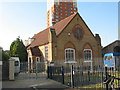
New Testament church, Bawtree Road, Deptford
The building looks as if was originally a school rather than a church, and from its architectural style certainly pre-dates the housing all around it.
Image: © Stephen Craven
Taken: 1 Jun 2009
0.07 miles
7
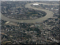
The Isle of Dogs from the air
Taken from a Heathrow bound flight from Glasgow on a grey August day. New Cross railway station can be seen in the lower left corner.
Image: © Thomas Nugent
Taken: 10 Aug 2016
0.07 miles
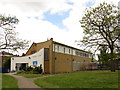
8
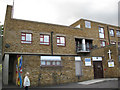
St Michael's community centre, Hatcham
Most of the building is used as a nursery on weekdays and a community centre at other times, but on Sundays part is used as a joint United Reformed / Anglican church.
Image: © Stephen Craven
Taken: 29 Jun 2007
0.08 miles
10
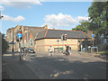
Toucan crossing, Edward Street, Deptford
A Toucan crossing is one designed for cyclists as well as pedestrians. This one is where part of the London Cycle Network crosses Edward Street at the northern end of Fordham Park Image
In the background is the Lower School building of Deptford Green comprehensive school. I did not know when I took the photo that it was scheduled for demolition: for construction of its replacement, see Image
Image: © Stephen Craven
Taken: 1 Jun 2009
0.08 miles