IMAGES TAKEN NEAR TO
Trim Street, LONDON, SE14 6EQ
Introduction
This page details the photographs taken nearby to Trim Street, SE14 6EQ by members of the Geograph project.
The Geograph project started in 2005 with the aim of publishing, organising and preserving representative images for every square kilometre of Great Britain, Ireland and the Isle of Man.

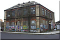
There are currently over 7.5m images from over14,400 individuals and you can help contribute to the project by visiting https://www.geograph.org.uk
Image Map
Images are licensed for reuse under creativecommons.org/licenses/by-sa/2.0
Notes
- Clicking on the map will re-center to the selected point.
- The higher the marker number, the further away the image location is from the centre of the postcode.
Image Listing (132 Images Found)
Images are licensed for reuse under creativecommons.org/licenses/by-sa/2.0
Image
Details
Distance
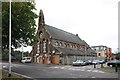
2
Celestial Church of Christ
A mainly Nigerian congregation, who wear white robes (as can be seen here). The building was formerly St Mark's (Church of England).
Image: © Stephen Craven
Taken: 15 Oct 2006
0.03 miles
5
Safa House, Arklow Street
This, long derelict, building was originally The Stone Institute. Connected to the Stone Foundry it was a social centre for the foundry workers.
Image: © Robert Eva
Taken: 4 Jan 2020
0.05 miles
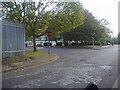
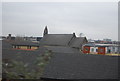
7
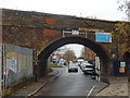
The arches at Edward Street and Wotton Road, Deptford
The railway tracks above these arches are the London Bridge to Deptford lines.
Image: © David Lunn
Taken: 30 Sep 2010
0.06 miles
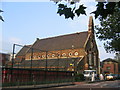
8
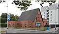
Olivet Deptford Baptist Church, Edward Street
Image: © John Salmon
Taken: 8 Oct 2011
0.07 miles
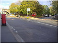
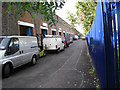
9
Edward Street, Deptford
One carriageway of Edward street passes under a railway arch just west of Deptford Station. Note the old height restriction sign - although in fact vehicles would not normally head through the arch in this direction. The blue sign gives directions to Network Rail's arches 210-227.
Image: © Stephen McKay
Taken: 1 Dec 2018
0.08 miles
10
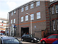
New Deptford Police Station on Amersham Vale, New Cross
This new Deptford police station is located next to the old police station.
Image: © David Lunn
Taken: 30 Sep 2010
0.08 miles