IMAGES TAKEN NEAR TO
Sterling Gardens, LONDON, SE14 6DU
Introduction
This page details the photographs taken nearby to Sterling Gardens, SE14 6DU by members of the Geograph project.
The Geograph project started in 2005 with the aim of publishing, organising and preserving representative images for every square kilometre of Great Britain, Ireland and the Isle of Man.

There are currently over 7.5m images from over14,400 individuals and you can help contribute to the project by visiting https://www.geograph.org.uk
Image Map
Images are licensed for reuse under creativecommons.org/licenses/by-sa/2.0
Notes
- Clicking on the map will re-center to the selected point.
- The higher the marker number, the further away the image location is from the centre of the postcode.
Image Listing (107 Images Found)
Images are licensed for reuse under creativecommons.org/licenses/by-sa/2.0
Image
Details
Distance
1
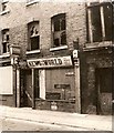
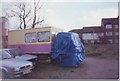
The end of the News - all human life was there
The news of the closure of the News of the World reminded me wistfully of this picture of a boarded-up shop awaiting demolition, taken for a college project back in 1969. It was, I recall in Amersham Vale though after 42 years I cannot be absolutely sure of its precise location. An innocent age long before 'phone hacking!
Image: © Chris Denny
Taken: Unknown
0.03 miles
7
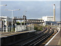
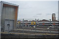
New Cross Gate station: view looking north
On 1 December 2015, the Southern Railway was not having one of its better days, so the protracted interval between trains allowed plenty of time for this photograph, where the most prominent feature is the new (2010) viaduct which carries the northbound Overground line above the SR tracks, on its way to join the East London line to Dalston Junction.
Image: © Dr Neil Clifton
Taken: 1 Dec 2015
0.09 miles
8
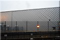
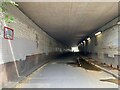
Long crossing, Cold Blow Lane, New Cross Gate
Looking west. It could be subtitled 'Under the Overground'. The bridge is named, not by Network Rail but by the Railway Authority as Bridge EL49 Cold Blow Lane Road Bridge (Deck E), owned not by Network Rail but by London Overground. It carries northbound and southbound tracks of the Overground, formerly the East London Line, serving New Cross Gate, West Croydon and Crystal Palace. Between the tracks are maintenance facilities and sidings for parking the five-coach trains.
Photo number 7872423.
Image: © Robin Stott
Taken: 29 Aug 2024
0.10 miles
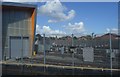
10
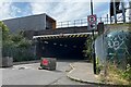
Long crossing, Cold Blow Lane, New Cross Gate
Looking east. It could be subtitled 'Under the Overground'. The bridge is named, not by Network Rail but by the Railway Authority as Bridge EL49 Cold Blow Lane Road Bridge (Deck E), owned not by Network Rail but by London Overground. It carries northbound and southbound tracks of the Overground, formerly the East London Line, serving New Cross Gate, West Croydon and Crystal Palace. Between the tracks are maintenance facilities and sidings for parking the five-coach trains.
Photo number 7872417.
Image: © Robin Stott
Taken: 29 Aug 2024
0.11 miles