IMAGES TAKEN NEAR TO
John Williams Close, LONDON, SE14 5XG
Introduction
This page details the photographs taken nearby to John Williams Close, SE14 5XG by members of the Geograph project.
The Geograph project started in 2005 with the aim of publishing, organising and preserving representative images for every square kilometre of Great Britain, Ireland and the Isle of Man.

There are currently over 7.5m images from over14,400 individuals and you can help contribute to the project by visiting https://www.geograph.org.uk
Image Map
Images are licensed for reuse under creativecommons.org/licenses/by-sa/2.0
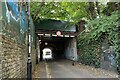
Notes
- Clicking on the map will re-center to the selected point.
- The higher the marker number, the further away the image location is from the centre of the postcode.
Image Listing (77 Images Found)
Images are licensed for reuse under creativecommons.org/licenses/by-sa/2.0
Image
Details
Distance
1
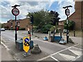
Traffic control, New Cross Gate
Restrictions are in place on Cold Blow Lane, partly explained in Image
Photo number 7872243.
Image: © Robin Stott
Taken: 29 Aug 2024
0.03 miles
2
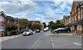
North on Cold Blow Lane, New Cross Gate
Cold Blow Lane will shortly turn east under the railway. A map of around 1900 shows it threading its way beneath an explosion of railway lines, past Coldblow Farm to connect to Knoyle Street. There are two exotic plants in the view: Oleander in flower, left, and Date Palm, ahead. As the climate warms some exotics could go native: Date Palms overrunning Deptford.
Photo number 7872064.
Image: © Robin Stott
Taken: 29 Aug 2024
0.04 miles
4
Hunsdon Road, New Cross Gate
On the left is the commanding frontage of Haberdashers' Hatcham Primary School. Red-and-white signs to the right proclaim 'New Road Layout Ahead'; 'No access to Sanford Street via Cold Blow Lane except authorised vehicles'. Cold Blow Lane will be on my route to follow the Overground.
Photo number 7871963.
Image: © Robin Stott
Taken: 29 Aug 2024
0.07 miles
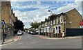
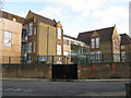
6
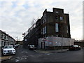
Hatcham Temple Grove School, New Cross
The roof and second floor of the school were badly damaged by fire on 6th April 2010.
Image: © PAUL FARMER
Taken: 26 Dec 2011
0.08 miles
8
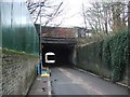
East on Cold Blow Lane, New Cross Gate
According to a map from the nineteenth century, nearest the camera was once a bridge carrying a single line to sidings on the west side of New Cross Gate station. The next crossing took tracks to a range of coke ovens. The third and widest crossing carried the main line of the London Brighton & South Coast Railway. https://maps.nls.uk/geo/explore/side-by-side/#zoom=16.9&lat=51.48162&lon=-0.04450&layers=257&right=osm
Photo number 7872324.
Image: © Robin Stott
Taken: 29 Aug 2024
0.08 miles
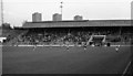
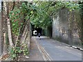
9
Short crossing, Cold Blow Lane, New Cross Gate
Looking east. The bridge carries the four-track London-Brighton main line (from London Bridge) and a fifth track. Trains can be heard but not seen.
Photo number 7872361.
Image: © Robin Stott
Taken: 29 Aug 2024
0.09 miles
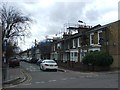
10
New Cross: Haberdashers Askes Hatcham College
On Monson Road
Image: © Dr Neil Clifton
Taken: 1 Dec 2015
0.09 miles