IMAGES TAKEN NEAR TO
Samuel Close, LONDON, SE14 5RP
Introduction
This page details the photographs taken nearby to Samuel Close, SE14 5RP by members of the Geograph project.
The Geograph project started in 2005 with the aim of publishing, organising and preserving representative images for every square kilometre of Great Britain, Ireland and the Isle of Man.

There are currently over 7.5m images from over14,400 individuals and you can help contribute to the project by visiting https://www.geograph.org.uk
Image Map
Images are licensed for reuse under creativecommons.org/licenses/by-sa/2.0
Notes
- Clicking on the map will re-center to the selected point.
- The higher the marker number, the further away the image location is from the centre of the postcode.
Image Listing (113 Images Found)
Images are licensed for reuse under creativecommons.org/licenses/by-sa/2.0
Image
Details
Distance
2

New rail flyover at New Cross Gate
This new flyover was constructed in 2008 to allow trains from south of New Cross Gate to access the former East London Line without conflicting with main line services, once the new London Overground service starts in 2010.
Image: © Stephen Craven
Taken: 26 Aug 2008
0.07 miles
3
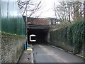
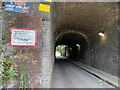
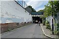
Short crossing, Cold Blow Lane, New Cross Gate
Looking east. The bridge carries the four-track London-Brighton main line (from London Bridge) and a fifth track. Trains can be heard but not seen.
Photo number 7872361.
Image: © Robin Stott
Taken: 29 Aug 2024
0.08 miles
4
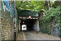
East on Cold Blow Lane, New Cross Gate
According to a map from the nineteenth century, nearest the camera was once a bridge carrying a single line to sidings on the west side of New Cross Gate station. The next crossing took tracks to a range of coke ovens. The third and widest crossing carried the main line of the London Brighton & South Coast Railway. https://maps.nls.uk/geo/explore/side-by-side/#zoom=16.9&lat=51.48162&lon=-0.04450&layers=257&right=osm
Photo number 7872324.
Image: © Robin Stott
Taken: 29 Aug 2024
0.08 miles
5
Knoyle Street from Cold Blow Lane
The bridge abutments in the foreground are the remnants of the branch to Deptford Wharf, closed in 1964.
Image: © Robert Eva
Taken: 4 Jan 2020
0.08 miles
6
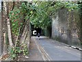
Short crossing, Cold Blow Lane, New Cross Gate
Looking east. The inner, older part of Bridge ELR-LBW Structure 218 Cold Blow Lane. It carries the four-track main line from London Bridge to Brighton plus a fifth track.
Photo number 7872392.
Image: © Robin Stott
Taken: 29 Aug 2024
0.08 miles
7
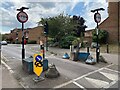
Traffic control, New Cross Gate
Restrictions are in place on Cold Blow Lane, partly explained in Image
Photo number 7872243.
Image: © Robin Stott
Taken: 29 Aug 2024
0.09 miles
9
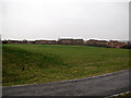
Bridge House Meadows
An open space to the east of the London Overground railway line.
Image: © Stephen Craven
Taken: 18 Jan 2013
0.09 miles
10
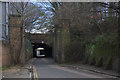
Short crossing, Cold Blow Lane, New Cross Gate
Looking west. The bridge carries the four-track London-Brighton main line (from London Bridge) and a fifth track. The bridge is identified by Network Rail as ELR-LBW Structure 218 Cold Blow Lane. Trains can be heard but not seen.
Photo number 7972403.
Image: © Robin Stott
Taken: 29 Aug 2024
0.09 miles