IMAGES TAKEN NEAR TO
Porlock Street, LONDON, SE1 3RY
Introduction
This page details the photographs taken nearby to Porlock Street, SE1 3RY by members of the Geograph project.
The Geograph project started in 2005 with the aim of publishing, organising and preserving representative images for every square kilometre of Great Britain, Ireland and the Isle of Man.

There are currently over 7.5m images from over14,400 individuals and you can help contribute to the project by visiting https://www.geograph.org.uk
Image Map
Images are licensed for reuse under creativecommons.org/licenses/by-sa/2.0
Notes
- Clicking on the map will re-center to the selected point.
- The higher the marker number, the further away the image location is from the centre of the postcode.
Image Listing (1083 Images Found)
Images are licensed for reuse under creativecommons.org/licenses/by-sa/2.0
Image
Details
Distance
1
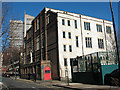
Charterhouse-in-Southwark
The 'Charterhouse Mission' as it was then, was set up by old boys of Charterhouse School in April 1885 as part of the "settlement movement". http://en.wikipedia.org/wiki/Settlement_movement This building in Crosby Row, including St Hugh's Church, gym and working mens club, was built c.1908.
As of 2010, the organisation only operates a nursery, and the future of this building is uncertain. The website is http://www.charterhouse-in-southwark.org.uk/
[Update 2013: the building in the photos has been demolished and the site is being redeveloped]
Image: © Stephen Craven
Taken: 2 Mar 2010
0.00 miles
2
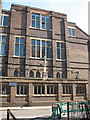
St Hugh's church, Bermondsey - west end
The church - a licensed place of worship in the parish of St Saviour (Southwark Cathedral) - is part of the Charterhouse building: see Image Its future was uncertain as of 2010.
Image: © Stephen Craven
Taken: 2 Mar 2010
0.00 miles
3
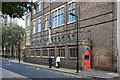
St Hugh, Crosby Row, London SE1
Charterhouse Mission Church
Image: © John Salmon
Taken: 16 Oct 2010
0.00 miles
4
Replacement for the Rainbow Building
The local landmark “rainbow building” Image on Crosby Row, including St Hugh’s Church, was being replaced by this new building including a worship space and community centre on the ground floor.
Image: © Stephen Craven
Taken: 19 Jul 2013
0.00 miles
6
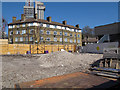
Site of the former Charterhouse Mission
The mission building Image was demolished in 2011 and construction of the replacement development of apartments, community centre and place of worship would shortly begin. Guy's tower and the lower part of the Shard can be seen in the distance beyond Porlock Street.
Image: © Stephen Craven
Taken: 27 Mar 2012
0.01 miles
7
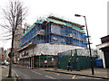
Rebuilding on the Charterhouse site
The site of the former Charterhouse Mission on Crosby Row Image, last seen after demolition Image, now partly rebuilt. It is no longer owned by Charterhouse.
Image: © Stephen Craven
Taken: 1 Feb 2013
0.01 miles
8
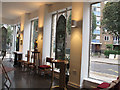
Interior of the new St Hugh's Bermondsey
The new church consists of the ground floor of an apartment block. See Image
Image: © Stephen Craven
Taken: 11 Sep 2014
0.01 miles
9
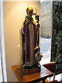
Statue of St Hugh
Inside the church in Bermondsey that bears his name. For context see Image The statue of St Hugh of Lincoln (with the goose that is his symbol) came from the old church - see Image
Image: © Stephen Craven
Taken: 11 Sep 2014
0.01 miles
10
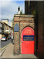
St Hugh's Church, The Borough
Doorway in Crosby Row. This late Victorian church is the Anglican parish church for West Bermondsey.
Image: © Stephen McKay
Taken: 14 Sep 2007
0.01 miles