IMAGES TAKEN NEAR TO
Whites Grounds Estate, LONDON, SE1 3JZ
Introduction
This page details the photographs taken nearby to Whites Grounds Estate, SE1 3JZ by members of the Geograph project.
The Geograph project started in 2005 with the aim of publishing, organising and preserving representative images for every square kilometre of Great Britain, Ireland and the Isle of Man.

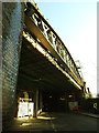
There are currently over 7.5m images from over14,400 individuals and you can help contribute to the project by visiting https://www.geograph.org.uk
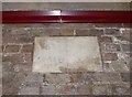
Image Map
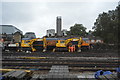
Images are licensed for reuse under creativecommons.org/licenses/by-sa/2.0
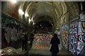
Notes
- Clicking on the map will re-center to the selected point.
- The higher the marker number, the further away the image location is from the centre of the postcode.
Image Listing (1118 Images Found)
Images are licensed for reuse under creativecommons.org/licenses/by-sa/2.0
Image
Details
Distance
1
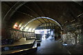
View through White's Grounds Skate Park out onto White's Grounds
Looking south-southwest.
Image: © Robert Lamb
Taken: 27 Jan 2019
0.00 miles
2
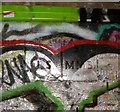
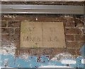
Old Boundary Marker on railway bridge, Southward Parish
Parish Boundary Marker in parish of Southwark (Southwark District), on Railway Bridge next to White's Grounds, arch now used as skatepark, high on wall.
Surveyed
Milestone Society National ID: SY_SJSSMMB05pb
Image: © Milestone Society
Taken: Unknown
0.01 miles
3
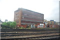
Offices by the railway line
At the approaches to London Bridge Station.
Image: © N Chadwick
Taken: 12 Jun 2011
0.01 miles
4
View down White's Grounds
Looking south-southwest.
Image: © Robert Lamb
Taken: 27 Jan 2019
0.01 miles
5
Crucifix Lane railway bridge
The bridge takes the main lines out of London Bridge station over Crucifix Lane at an oblique angle. Barnham Street is to the left.
Image: © Stephen Craven
Taken: 20 Dec 2013
0.01 miles
6
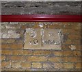
Old Boundary Marker by White's Grounds, Southwark
Parish Boundary Marker by the UC road, in parish of Southwark (Southwark District), White's Grounds SE1, inside Eastern railway arch, high up, Northwest side of road.
Inscription reads:-
: Sᵀ. / M.M.B : : Sᵀ. / J.S :
Surveyed
Milestone Society National ID: SY_SJSSMMB02pb
Image: © Milestone Society
Taken: Unknown
0.02 miles
7
Engineering works outside London Bridge Station
Image: © N Chadwick
Taken: 31 Aug 2015
0.02 miles
8
View inside White's Grounds Skate Park on Druid Street #2
Looking north-northwest.
Image: © Robert Lamb
Taken: 27 Jan 2019
0.02 miles
9
Old Boundary Marker by White's Grounds tunnel, Southwark parish
Parish Boundary Marker in parish of Southwark (Southwark District), under bridge next to White's Grounds, high on wall on Northwest side of road.
Inscription reads:-
: ST / MMB : : ST / JS :
(St Mary Magdalene Bermondsey and St John Southwark)
Surveyed
Milestone Society National ID: SY_SJSSMMB04pb
Image: © Milestone Society
Taken: Unknown
0.03 miles
10
Old Boundary Marker by the A2207, Crucifix Lane
Parish Boundary Marker by the A2207, in parish of Bermondsey Rotherhithe and Southwark (Southwark District), Crucifix Lane SE1, under railway arch, high up, Southeast side of road.
Surveyed
Milestone Society National ID: SY_SJSSMMB03pb
Image: © Milestone Society
Taken: Unknown
0.03 miles