IMAGES TAKEN NEAR TO
Tyers Estate, Bermondsey Street, LONDON, SE1 3JG
Introduction
This page details the photographs taken nearby to Tyers Estate, Bermondsey Street, SE1 3JG by members of the Geograph project.
The Geograph project started in 2005 with the aim of publishing, organising and preserving representative images for every square kilometre of Great Britain, Ireland and the Isle of Man.

There are currently over 7.5m images from over14,400 individuals and you can help contribute to the project by visiting https://www.geograph.org.uk
Image Map
Images are licensed for reuse under creativecommons.org/licenses/by-sa/2.0
Notes
- Clicking on the map will re-center to the selected point.
- The higher the marker number, the further away the image location is from the centre of the postcode.
Image Listing (913 Images Found)
Images are licensed for reuse under creativecommons.org/licenses/by-sa/2.0
Image
Details
Distance
1
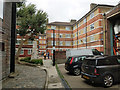
Tyers Estate, Bermondsey
Looking down Carmarthen Place.
Image: © Robin Webster
Taken: 19 Sep 2018
0.02 miles
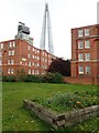
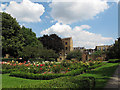
2
Leathermarket Gardens, Bermondsey
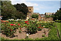
The name of Leathermarket Gardens comes from the historic leather markets and tanneries nearby. The park was laid out in the 1930s, and the gardens are overlooked by flats of the same period. It is a popular sitting out area for local workers. Rising above everything else in the background is The Shard which was nearing completion when the photograph was taken. This will be the tallest building in the European Union at 1,017 feet. Above it is Europe's highest crane and a number of newspaper articles have featured what it is like to be in the cab of the crane.
Image: © Marathon
Taken: 14 Oct 2011
0.02 miles
3
Leathermarket Gardens
The name of Leathermarket Gardens comes from the historic leather markets and tanneries nearby. The park was laid out in the 1930s. It is a popular sitting out area for local workers.
Image: © Marathon
Taken: 14 Oct 2011
0.04 miles
4
Leathermarket Gardens
The name of Leathermarket Gardens comes from the historic leather markets and tanneries nearby. The park was laid out in the 1930s, and the gardens are overlooked by flats of the same period. It is a popular sitting out area for local workers. Rising above everything else in the background is The Shard. When I took the same photograph in October 2011 The Shard was still being built - https://www.geograph.org.uk/photo/2647620
Image: © Marathon
Taken: 24 Oct 2020
0.04 miles
5
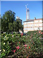
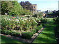
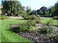
Leathermarket Gardens - rose garden
Rose garden at the eastern end of the park.
Image: © Stephen Craven
Taken: 9 Aug 2012
0.04 miles
6
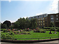
Making the most of the sunshine
On one of the few sunny days in the summer of 2012, city workers enjoy the sunshine in Leathermarket Gardens.
Image: © Stephen Craven
Taken: 9 Aug 2012
0.04 miles
7
Leathermarket Gardens
The name of Leathermarket Gardens comes from the historic leather markets and tanneries nearby. The park was laid out in the 1930s. It is a popular sitting out area for local workers.
Image: © Marathon
Taken: 14 Oct 2011
0.04 miles
8
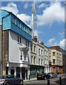
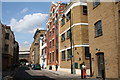
68-78 Bermondsey Street
Mostly C18th (at least externally), but no. 78, nearest, is late C17th and weatherboarded. What function did it serve? Grade II listed.
Lowering behind is the Shard.
Image: © Stephen Richards
Taken: 27 May 2013
0.04 miles