IMAGES TAKEN NEAR TO
Millstream Road, LONDON, SE1 3FH
Introduction
This page details the photographs taken nearby to Millstream Road, SE1 3FH by members of the Geograph project.
The Geograph project started in 2005 with the aim of publishing, organising and preserving representative images for every square kilometre of Great Britain, Ireland and the Isle of Man.

There are currently over 7.5m images from over14,400 individuals and you can help contribute to the project by visiting https://www.geograph.org.uk
Image Map (Loading...)


Getting Data...Please wait
Leaflet Map data © OpenStreetMap
Images are licensed for reuse under creativecommons.org/licenses/by-sa/2.0
Notes
- Clicking on the map will re-center to the selected point.
- The higher the marker number, the further away the image location is from the centre of the postcode.
Image Listing (378 Images Found)
Images are licensed for reuse under creativecommons.org/licenses/by-sa/2.0
Image
Details
Distance
1
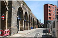
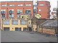
Bermondsey: Ropewalk
A number of small businesses have their premises under the arches here.
Image: © Dr Neil Clifton
Taken: 20 Jun 2012
0.01 miles
3
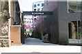
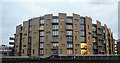
Wharton House
Apartments at Millstream Road.
Image: © Oast House Archive
Taken: 26 Jun 2011
0.03 miles
5

London Bridge railway station from the air
Viewed through a gap in the clouds on the way to Heathrow from the east.
Image: © Thomas Nugent
Taken: 28 Feb 2019
0.04 miles
8
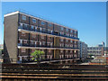
Trackside scenery and graffiti, Bermondsey
I'm not a big fan of graffiti, but I confess to a soft spot for Gold Peg and Monkey; this particular oeuvre has been on this building for a couple of years, surviving despite various opportunities to erase it, so presumably someone else feels the same.
Image: © Christopher Hilton
Taken: 2 Jun 2011
0.06 miles
9
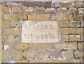
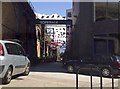
Old Boundary Marker under railway arch, Tanner Street, Bermondsey
Parish Boundary Marker by the UC road, in parish of Bermondsey Rotherhithe and Southwark (Southwark District), Tanner Street SE1, under railway arch, high up, South East side of road.
Surveyed
Milestone Society National ID: SY_SMMB01pb
Image: © Milestone Society
Taken: Unknown
0.06 miles