IMAGES TAKEN NEAR TO
Purbrook Estate, Tower Bridge Road, LONDON, SE1 3BZ
Introduction
This page details the photographs taken nearby to Purbrook Estate, Tower Bridge Road, SE1 3BZ by members of the Geograph project.
The Geograph project started in 2005 with the aim of publishing, organising and preserving representative images for every square kilometre of Great Britain, Ireland and the Isle of Man.

There are currently over 7.5m images from over14,400 individuals and you can help contribute to the project by visiting https://www.geograph.org.uk
Image Map
Images are licensed for reuse under creativecommons.org/licenses/by-sa/2.0
Notes
- Clicking on the map will re-center to the selected point.
- The higher the marker number, the further away the image location is from the centre of the postcode.
Image Listing (381 Images Found)
Images are licensed for reuse under creativecommons.org/licenses/by-sa/2.0
Image
Details
Distance
1
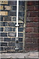
Benchmark on #160 Tower Bridge Road
Ordnance Survey cut mark benchmark described on the Bench Mark Database at http://www.bench-marks.org.uk/bm37861
Image: © Roger Templeman
Taken: 6 May 2011
0.02 miles
2
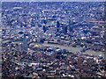
City of London from the air
Many iconic buildings, ancient and modern, can be seen here, including Tower Bridge, the Tower of London, Norman Fosters City Hall and Swiss Re Building (aka the gherkin) and The Shard.
Image: © Thomas Nugent
Taken: 29 Aug 2011
0.04 miles
3
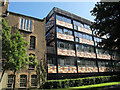
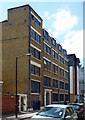
4 Newhams Row, Bermondsey (rear)
This colourful office block was built a few years ago. The entrance is on Newhams Row (the other side) but it backs onto St Mary's churchyard. It is the home of various charities.
Image: © Stephen Craven
Taken: 21 May 2015
0.06 miles
4
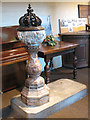
Font in St Mary's church, Bermondsey
The font dates from 1808, and is no longer in regular use.
Image: © Stephen Craven
Taken: 19 May 2009
0.06 miles
5
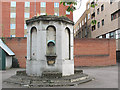
All that's left of St Olave's?
This drinking fountain (no longer working) in Tanner Street Park was, according to local lore, formed from part of the tower of St Olave's church when it was demolished in 1926. For the site of the church and the building that now stands there, see Image
I have since found that the answer to the question is "no": the bell, pulpit and some other fittings went to a church in Mitcham that also took the name of St Olave's. See Image and Image
Image: © Stephen Craven
Taken: 22 Jul 2009
0.07 miles
6
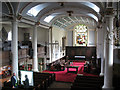
Interior of St Mary's church, Bermondsey
The inside of the grade 2* listed parish church Image viewed from the balcony.
The church is essentially early Georgian, 1675-9 but the interior was "remodelled" in the 19th century and the chancel lengthened in 1883. See the parish website http://www.stmarysbermondsey.org.uk
Image: © Stephen Craven
Taken: 19 May 2009
0.07 miles
7
54-58 Tanner Street
Former warehouse, perhaps early C20th.
Now seemingly offices.
Image: © Stephen Richards
Taken: 27 May 2013
0.07 miles
8
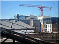
Roof top view
Seen from the railway approaching London Bridge.
Image: © Oast House Archive
Taken: 26 Jun 2011
0.07 miles
9

Benchmark on gateway to former school at #54-58 Tanner Street
Ordnance Survey cut mark benchmark described on the Bench Mark Database at http://www.bench-marks.org.uk/bm37862
Image: © Roger Templeman
Taken: 6 May 2011
0.08 miles
10
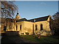
St Mary Magdalen Church, Bermondsey, London viewed from the churchyard
Image: © Richard Rogerson
Taken: 10 Dec 2009
0.08 miles