IMAGES TAKEN NEAR TO
Grange Road, LONDON, SE1 3BT
Introduction
This page details the photographs taken nearby to Grange Road, SE1 3BT by members of the Geograph project.
The Geograph project started in 2005 with the aim of publishing, organising and preserving representative images for every square kilometre of Great Britain, Ireland and the Isle of Man.

There are currently over 7.5m images from over14,400 individuals and you can help contribute to the project by visiting https://www.geograph.org.uk
Image Map
Images are licensed for reuse under creativecommons.org/licenses/by-sa/2.0
Notes
- Clicking on the map will re-center to the selected point.
- The higher the marker number, the further away the image location is from the centre of the postcode.
Image Listing (232 Images Found)
Images are licensed for reuse under creativecommons.org/licenses/by-sa/2.0
Image
Details
Distance
1
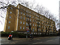
Bridge View Court, Grange Road
A large six-storey housing block.
Image: © Stephen Craven
Taken: 25 Jan 2014
0.00 miles
2
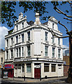
209 Grange Road
A well gabled building which screams 'pub'. Dated 1898.
Not sure it was occupied at the time.
Image: © Stephen Richards
Taken: 27 May 2013
0.02 miles
3
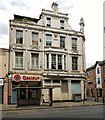
Qasioun Lebanese Restaurant
Occupying part of the 1898 dated building on the corner of Grange Road and Grigg's Place is the Qasioun Lebanese Restaurant. It had previously been a sandwich bar. The main building was originally a pub called the Samsons Castle https://pubshistory.com/LondonPubs/Bermondsey/SamsonsCastle.shtml and has been vacant for more than a decade.
Image: © Gerald England
Taken: 18 Jul 2018
0.02 miles
4

House, Grange Road, London SE1
One of the old houses in Grange Road. Looks as though at one time there was a shop on the ground floor.
Image: © Christine Matthews
Taken: 8 Mar 2015
0.03 miles
5
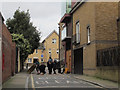
Filming on Grigg's Place
These appeared to be arts students using this quiet back street in Bermondsey for a photo shoot.
Image: © Stephen Craven
Taken: 8 Mar 2015
0.03 miles
6

Bermondsey United Charity School for Girls
There is no doubt when the school dates from as "Erected A.D 1830" appears under its name. It is on the corner of Grange Walk and Grigg's Place and is immediately beyond 8 - 11 Grange Walk which date from 1700 - see http://www.geograph.org.uk/photo/2650238
Image: © Marathon
Taken: 14 Oct 2011
0.03 miles
7
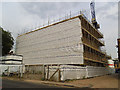
Apartments under construction, Pages Walk
Following on from the town houses across the road Image, Bellway Homes were constructing new apartments between Pages Walk and Crimscott Street in 2013.
Image: © Stephen Craven
Taken: 16 Jul 2013
0.04 miles
8
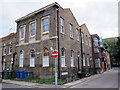
Former school, Grange Walk, Bermondsey
Bermondsey United Charity School for Girls in Grange Walk was erected AD 1830, according to the inscription. It was later used as St Mary’s youth centre but like many buildings in the area has now been converted for use as apartments. See also Image
Image: © Stephen Craven
Taken: 7 Oct 2013
0.04 miles
9

8 - 11 Grange Walk, Bermondsey
According to Pevsner, these houses in Grange Walk date from about 1700. Just beyond in this interesting street is the Bermondsey United Charity School for Girls - see http://www.geograph.org.uk/photo/2650252
Image: © Marathon
Taken: 14 Oct 2011
0.04 miles
10
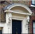
Detail of 11 Grange Walk
Doorcase of c1700 with elaborate carved brackets typical of that time.
Wider view: Image
Image: © Stephen Richards
Taken: 27 May 2013
0.04 miles