IMAGES TAKEN NEAR TO
Malyons Road, LONDON, SE13 7XF
Introduction
This page details the photographs taken nearby to Malyons Road, SE13 7XF by members of the Geograph project.
The Geograph project started in 2005 with the aim of publishing, organising and preserving representative images for every square kilometre of Great Britain, Ireland and the Isle of Man.

There are currently over 7.5m images from over14,400 individuals and you can help contribute to the project by visiting https://www.geograph.org.uk
Image Map
Images are licensed for reuse under creativecommons.org/licenses/by-sa/2.0
Notes
- Clicking on the map will re-center to the selected point.
- The higher the marker number, the further away the image location is from the centre of the postcode.
Image Listing (170 Images Found)
Images are licensed for reuse under creativecommons.org/licenses/by-sa/2.0
Image
Details
Distance
4
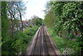
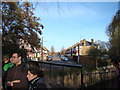
The Mid-Kent Line crosses the River Ravensbourne
The Mid-Kent Line was opened by the South Eastern Railway on 1st January 1857 between Lewisham and Beckenham Junction. The railway was originally planned to carry traffic along the border of the counties of Kent and Surrey, and on to Westerham and Sevenoaks, but never got further than Hayes which is now in the London Borough of Bromley. The Mid-Kent Line is therefore somewhat confusing and the line is now more usually referred to as the Hayes Branch. This view looks up the line towards Ladywell station in the distance.
The bridge in the foreground is where the River Ravensbourne flows under the line. During 2007-8, a new channel was created in the northern section of Ladywell Fields (to the right of the line here and in the distance) so that the River Ravensbourne could run through the park as well as follow its normal course. Under the line here though is the original concrete channel with the river flowing left to right.
Image: © Marathon
Taken: 12 Jul 2011
0.05 miles
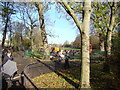
5
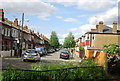
View of Malyons Road from Ladywell Fields
Looking north-northeast.
Image: © Robert Lamb
Taken: 25 Nov 2011
0.05 miles
6
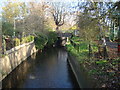
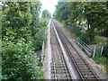
View of the railway crossing the Ravensbourne #2
Looking north-northeast.
Image: © Robert Lamb
Taken: 25 Nov 2011
0.06 miles
7
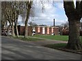
Ladywell Centre
"A day service for people with disabilities and sensory impairments aged 18 and above" http://www.horizones.org.uk/ladywell-centre.htm
Image: © Derek Harper
Taken: 11 Mar 2011
0.06 miles
8
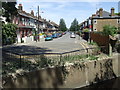
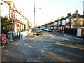
Malyons Road, Ladywell
Malyons Road comes to a dead end where it meets the Ravensbourne River. There is however a bridge for pedestrians and cyclists to cross the river, although it is not visible in this image.
Image: © Malc McDonald
Taken: 25 May 2011
0.06 miles
9
View of the play area in Ladywell Fields
Looking north-northeast.
Image: © Robert Lamb
Taken: 26 Nov 2011
0.06 miles
10
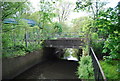
Railway bridge across the River Ravensbourne
Image: © N Chadwick
Taken: 12 May 2012
0.06 miles