IMAGES TAKEN NEAR TO
Bliss Crescent, LONDON, SE13 7RJ
Introduction
This page details the photographs taken nearby to Bliss Crescent, SE13 7RJ by members of the Geograph project.
The Geograph project started in 2005 with the aim of publishing, organising and preserving representative images for every square kilometre of Great Britain, Ireland and the Isle of Man.

There are currently over 7.5m images from over14,400 individuals and you can help contribute to the project by visiting https://www.geograph.org.uk
Image Map
Images are licensed for reuse under creativecommons.org/licenses/by-sa/2.0
Notes
- Clicking on the map will re-center to the selected point.
- The higher the marker number, the further away the image location is from the centre of the postcode.
Image Listing (184 Images Found)
Images are licensed for reuse under creativecommons.org/licenses/by-sa/2.0
Image
Details
Distance
1
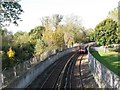
Docklands Light Railway north of Elverson Road DLR station
Looking north.
Image: © Mike Quinn
Taken: 28 Oct 2008
0.04 miles
2
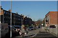
Coldbath Street
A hurried shot of Coldbath Street in Greenwich, where I'd gone with a load of timber to be delivered to a building site nearby. It's always a bit of a culture shock for me to leave rural Herefordshire, where I live, and spend the day in London. I have no doubt it's a fabulous place to live, but I'm always glad to get away from the place ... there are just too many humans there.
Image: © John Winder
Taken: 14 Jan 2015
0.04 miles
3
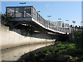
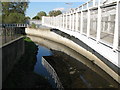
Pedestrian bridge over the River Ravensbourne near Elverson Road DLR station
Image: © Mike Quinn
Taken: 28 Oct 2008
0.04 miles
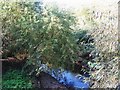
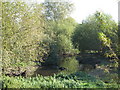
5
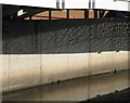
Reflections in, and of, the River Ravensbourne
Image: © Mike Quinn
Taken: 28 Oct 2008
0.05 miles
6
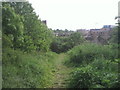
The former Greenwich Park railway at Brookmill Park
The London, Chatham & Dover Railway opened a line in 1871 with stations at Nunhead, Brockley Lane, Lewisham Road, and Blackheath Hill, to eventually reach Greenwich Park in 1888. Declining passenger numbers caused its closure in 1917 although the section from Nunhead to a point just east of Lewisham Road station was reopened to provide an alternative route into central London. Between the point where the Greenwich Park branch crossed over the main lines at St Johns and the terminus at Greenwich Park, the line was abandoned. This embankment at the southern end of Brookmill Park together with its continuation on the other side of Brookmill Road are the main indications now that this line ever existed beyond St Johns.
Image: © Marathon
Taken: 6 May 2011
0.05 miles
7
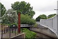
Entrance to Brookmill Park
Looking downstream on the Ravensbourne
Image: © Glyn Baker
Taken: 19 Jul 2017
0.05 miles
9
The River Ravensbourne north of Elverson Road DLR station (2)
Image: © Mike Quinn
Taken: 28 Oct 2008
0.06 miles
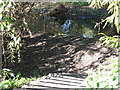
10
In deepest Lewisham
The River Ravensbourne in Ravensbourne Park.
Image: © Mike Quinn
Taken: 28 Oct 2008
0.06 miles