IMAGES TAKEN NEAR TO
Lewisham Road, LONDON, SE13 7PZ
Introduction
This page details the photographs taken nearby to Lewisham Road, SE13 7PZ by members of the Geograph project.
The Geograph project started in 2005 with the aim of publishing, organising and preserving representative images for every square kilometre of Great Britain, Ireland and the Isle of Man.

There are currently over 7.5m images from over14,400 individuals and you can help contribute to the project by visiting https://www.geograph.org.uk
Image Map
Images are licensed for reuse under creativecommons.org/licenses/by-sa/2.0
Notes
- Clicking on the map will re-center to the selected point.
- The higher the marker number, the further away the image location is from the centre of the postcode.
Image Listing (195 Images Found)
Images are licensed for reuse under creativecommons.org/licenses/by-sa/2.0
Image
Details
Distance
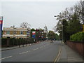
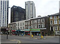
2
Orchard Estate, Lewisham (1)
Lewisham Road, near the junction with Conington Road.
Image: © Danny P Robinson
Taken: 17 May 2007
0.03 miles
3
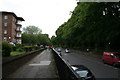
Lewisham: Lewisham Hill
Unusually, this road has a raised and fenced-off footway on both sides of the road, suggesting that in former times the road surface itself has been lowered.
Image: © Dr Neil Clifton
Taken: 16 Jun 2012
0.05 miles
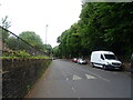


8
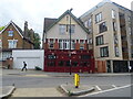
The Anchor, Lewisham
On Lewisham Road.
See Image] for sign.
Image: © JThomas
Taken: 24 Jun 2022
0.09 miles
9
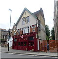
The Anchor, Lewisham
On Lewisham Road.
See Image] for sign.
Image: © JThomas
Taken: 24 Jun 2022
0.09 miles
10
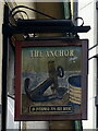
Sign for the Anchor, Lewisham
Image: © JThomas
Taken: 24 Jun 2022
0.09 miles