IMAGES TAKEN NEAR TO
Woodland Mews, LONDON, SE13 7LA
Introduction
This page details the photographs taken nearby to Woodland Mews, SE13 7LA by members of the Geograph project.
The Geograph project started in 2005 with the aim of publishing, organising and preserving representative images for every square kilometre of Great Britain, Ireland and the Isle of Man.

There are currently over 7.5m images from over14,400 individuals and you can help contribute to the project by visiting https://www.geograph.org.uk
Image Map
Images are licensed for reuse under creativecommons.org/licenses/by-sa/2.0
Notes
- Clicking on the map will re-center to the selected point.
- The higher the marker number, the further away the image location is from the centre of the postcode.
Image Listing (235 Images Found)
Images are licensed for reuse under creativecommons.org/licenses/by-sa/2.0
Image
Details
Distance
1
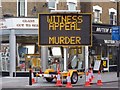
Police appeal, Loampit Hill SE13
Taken at the junction with Elswick Road
Image: © Robin Sones
Taken: 21 Feb 2012
0.03 miles
5
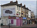
Shops on Loampit Vale SE13
At the junction with Elswick Road (South) - Elswick Road is a crescent and has two entrances on Loampit Hill
Image: © Robin Sones
Taken: 21 Feb 2012
0.04 miles
7
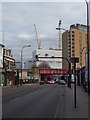
Loampit Vale SE13
Taken from the junction with Elswick Road (South)
Image: © Robin Sones
Taken: 21 Feb 2012
0.04 miles
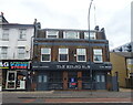
8

Sign for the Rising Sun, Lewisham
See Image] for context.
Image: © JThomas
Taken: 24 Jun 2022
0.05 miles

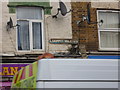
10
The Rising Sun, Lewisham
On Loampit Vale.
See Image] for sign.
Image: © JThomas
Taken: 24 Jun 2022
0.05 miles