IMAGES TAKEN NEAR TO
Thurston Road, LONDON, SE13 7JG
Introduction
This page details the photographs taken nearby to Thurston Road, SE13 7JG by members of the Geograph project.
The Geograph project started in 2005 with the aim of publishing, organising and preserving representative images for every square kilometre of Great Britain, Ireland and the Isle of Man.

There are currently over 7.5m images from over14,400 individuals and you can help contribute to the project by visiting https://www.geograph.org.uk
Image Map (276 Images)


Leaflet Map data © OpenStreetMap
Images are licensed for reuse under creativecommons.org/licenses/by-sa/2.0
Notes
- Clicking on the map will re-center to the selected point.
- The higher the marker number, the further away the image location is from the centre of the postcode.
Image Listing (276 Images Found)
Images are licensed for reuse under creativecommons.org/licenses/by-sa/2.0
Image
Details
Distance
1
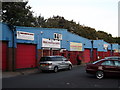
Churches in warehouses, Lewisham
This row of warehouses is beside Thurston Road.
Two are being used as religious meeting rooms.
Image: © David Anstiss
Taken: 25 Sep 2011
0.03 miles
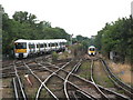
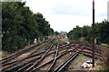
2
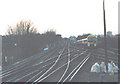
Railway tracks at dusk
Lewisham station covers the corner of 4 grid squares. This is the junction just west of the station - lines to Nunhead (left) and London Bridge (right).
Image: © Stephen Craven
Taken: 18 Jan 2003
0.03 miles
3
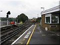
Looking west from Lewisham station
Lewisham is another station which has changed several times since its opening in 1849 as a simple two-platform station. Looking west here we see the two tracks occupied by trains, which lead to London Bridge, and to the left of them, the high-level lines which lead to ex-L. C. &D. tracks to Victoria. A connection put in, in 1976, also enables these tracks to serve London Bridge, by-passing the platforms at St. Johns.
Image: © Dr Neil Clifton
Taken: 24 Sep 2008
0.03 miles
6
Railway tracks west of Lewisham station
The right-hand pair of tracks lead to London Bridge and Charing Cross, while the left-hand pair on a steeply rising gradient, lead to Victoria. This photograph was taken from the extreme western end of Platform 2 at Lewisham station.
Image: © Dr Neil Clifton
Taken: 29 Aug 2012
0.03 miles
7
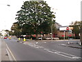
Road junction on Thurston Road
The A2210 Thurston Road leads from Deptford towards Lewisham. Jerrard Street links the A20 Loampit Vale with the road.
Image: © David Anstiss
Taken: 25 Sep 2011
0.04 miles