IMAGES TAKEN NEAR TO
Veda Road, LONDON, SE13 7JF
Introduction
This page details the photographs taken nearby to Veda Road, SE13 7JF by members of the Geograph project.
The Geograph project started in 2005 with the aim of publishing, organising and preserving representative images for every square kilometre of Great Britain, Ireland and the Isle of Man.

There are currently over 7.5m images from over14,400 individuals and you can help contribute to the project by visiting https://www.geograph.org.uk
Image Map
Images are licensed for reuse under creativecommons.org/licenses/by-sa/2.0
Notes
- Clicking on the map will re-center to the selected point.
- The higher the marker number, the further away the image location is from the centre of the postcode.
Image Listing (127 Images Found)
Images are licensed for reuse under creativecommons.org/licenses/by-sa/2.0
Image
Details
Distance
1
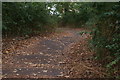
View down the steps in Hilly Fields Park
Looking south-southeast.
Image: © Robert Lamb
Taken: 19 Aug 2018
0.04 miles
2
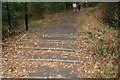
View up the steps in Hilly Fields Park
Looking north-northwest.
Image: © Robert Lamb
Taken: 19 Aug 2018
0.05 miles
3
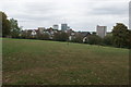
View over Lewisham from the top of the hill in Hilly Fields Park
Looking north-northeast.
Image: © Robert Lamb
Taken: 19 Aug 2018
0.08 miles
4

Vicars Hill, Lewisham (1)
Vicars Hill runs along the east side of Hilly Fields. This is the view southwards from the highest point on the road, towards Ladywell. For a closer view of the tower blocks in the distance, see Image
Image: © Stephen Craven
Taken: 13 Oct 2011
0.09 miles
5
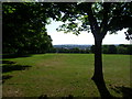
View from Hilly Fields
The summit of Hilly Fields stands 175 feet above sea level and gives extensive views across South London and towards Kent. Here, Shooters Hill with its distinctive water tower can be seen on the horizon. In the second half of the 19th century house building was proceeding rapidly in the area. Hilly Fields was saved from development by the protests of local residents. A committee of influential people was formed, which included Octavia Hill, the co-founder of the National Trust. She recorded that when visiting tenants in Deptford one day, she noticed a vase of freshly picked flowers, and on being told they had been picked on Hilly Fields, she set off to visit the area the same day. As a result she became instrumental in raising subscriptions to save Hilly Fields from being built over. The dedication of the park to the public took place in 1896.
Image: © Marathon
Taken: 31 May 2011
0.09 miles
6
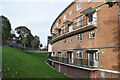
Curved block of flats below Vicars Hill
Image: © David Martin
Taken: 29 Oct 2022
0.09 miles
7
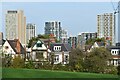
Houses by Hilly Fields Park, with Lewisham skyline
Ever-increasing high rise accommodation close to Lewisham Station.
Image: © David Martin
Taken: 29 Oct 2022
0.09 miles
8
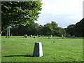
Triangulation Pillar, Hilly Fields near Brockley
A triangulation pillar (or "trig point") on Hilly Fields near Brockley in south east London. Triangulation pillars are generally situated on top of hills. By measuring the angles between adjacent triangulation pillars, map makers were able to determine the exact shape of the country.
A brief explanation about triangulation pillars can be found on the TrigPointingUK website http://www.trigpointinguk.com/info/trigpoints.php
Image: © Malc McDonald
Taken: 29 Jun 2011
0.10 miles
9
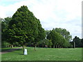
Hilly Fields, Brockley
Trees and a triangulation pillar on Hilly Fields in Brockley, South East London.
Triangulation pillars are generally situated on top of hills. By measuring the angles between adjacent triangulation pillars, map makers were able to determine the exact shape of the country.
A brief explanation about triangulation pillars can be found on the TrigPointingUK website http://www.trigpointinguk.com/info/trigpoints.php
Image: © Malc McDonald
Taken: 29 Jun 2011
0.10 miles
10
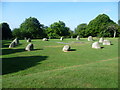
Stone circle on Hilly Fields
To mark the millennium, a stone circle of twelve large granite stones and two tall shadow-casting stones were erected near the summit of Hilly Fields.
Image: © Marathon
Taken: 31 May 2011
0.10 miles