IMAGES TAKEN NEAR TO
Algiers Road, LONDON, SE13 7JE
Introduction
This page details the photographs taken nearby to Algiers Road, SE13 7JE by members of the Geograph project.
The Geograph project started in 2005 with the aim of publishing, organising and preserving representative images for every square kilometre of Great Britain, Ireland and the Isle of Man.

There are currently over 7.5m images from over14,400 individuals and you can help contribute to the project by visiting https://www.geograph.org.uk
Image Map
Images are licensed for reuse under creativecommons.org/licenses/by-sa/2.0
Notes
- Clicking on the map will re-center to the selected point.
- The higher the marker number, the further away the image location is from the centre of the postcode.
Image Listing (143 Images Found)
Images are licensed for reuse under creativecommons.org/licenses/by-sa/2.0
Image
Details
Distance
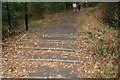
1
View down the steps in Hilly Fields Park
Looking south-southeast.
Image: © Robert Lamb
Taken: 19 Aug 2018
0.07 miles
4
View up the steps in Hilly Fields Park
Looking north-northwest.
Image: © Robert Lamb
Taken: 19 Aug 2018
0.08 miles
7
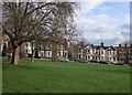
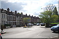
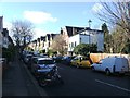
Houses on Eastern Road
This is part of the Brockley Conservation Area. Eastern Road is a no through road climbing into Hilly Fields Park and to Prendergast - Hilly Fields College. Writer Henry Williamson was raised at number 21, the white-painted house on the left.
Image: © Derek Harper
Taken: 11 Mar 2011
0.11 miles
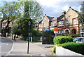
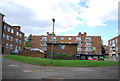
8
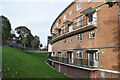
Curved block of flats below Vicars Hill
Image: © David Martin
Taken: 29 Oct 2022
0.11 miles