IMAGES TAKEN NEAR TO
Molesworth Street, LONDON, SE13 7HF
Introduction
This page details the photographs taken nearby to Molesworth Street, SE13 7HF by members of the Geograph project.
The Geograph project started in 2005 with the aim of publishing, organising and preserving representative images for every square kilometre of Great Britain, Ireland and the Isle of Man.

There are currently over 7.5m images from over14,400 individuals and you can help contribute to the project by visiting https://www.geograph.org.uk
Image Map
Images are licensed for reuse under creativecommons.org/licenses/by-sa/2.0
Notes
- Clicking on the map will re-center to the selected point.
- The higher the marker number, the further away the image location is from the centre of the postcode.
Image Listing (300 Images Found)
Images are licensed for reuse under creativecommons.org/licenses/by-sa/2.0
Image
Details
Distance
1
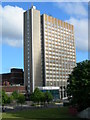
Lewisham House, 25 Molesworth Street, SE13 7EX
This is an operations centre for Citibank. It is a prominent landmark in the Lewisham area.
Image: © Danny P Robinson
Taken: 13 May 2007
0.03 miles
2
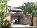
Subway to the town centre
This old subway beneath the railway lines south of Lewisham station has a new lease of life connecting the town centre shops (below the multi-storey carpark in the background) with newer residential area around Cornmill Gardens to the west.
Image: © Stephen Craven
Taken: 19 Sep 2009
0.03 miles
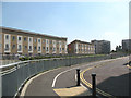
3
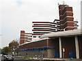
Rear of the Lewisham Centre
In the foreground is the ramp bringing cars down from the multi-storey car park (background) over the shopping centre, with an office block as part of the same (1970s?) development.
Image: © Stephen Craven
Taken: 19 Sep 2009
0.05 miles
4
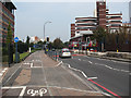
Molesworth Street, Lewisham
This is in effect the Lewisham inner bypass or relief road - a dual carriageway to the west of the shopping centre, with segregated cycle lanes. See also Image
Image: © Stephen Craven
Taken: 19 Sep 2009
0.05 miles
5
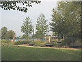
Cornmill Gardens (3)
A tranquil corner of the gardens.
Image: © Stephen Craven
Taken: 19 Sep 2009
0.05 miles
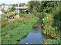
6
The River Ravensbourne in Cornmill Gardens (5)
For info about the gardens, see Lewisham Council's website http://www.lewisham.gov.uk/LeisureAndCulture/ParksAndRecreation/LocalParks/CornmillGardens.htm and http://www.therrc.co.uk/case_studies/cornmill%20gardens.pdf.
Image: © Mike Quinn
Taken: 5 Aug 2009
0.06 miles
7
The River Ravensbourne in Cornmill Gardens (3)
For info about the gardens, see Lewisham Council's website http://www.lewisham.gov.uk/LeisureAndCulture/ParksAndRecreation/LocalParks/CornmillGardens.htm and http://www.therrc.co.uk/case_studies/cornmill%20gardens.pdf.
Image: © Mike Quinn
Taken: 5 Aug 2009
0.06 miles
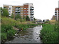
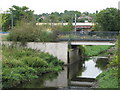
8
Cornmill Gardens (2)
A view in the opposite direction from Image: the River Ravensbourne is behind the railings, with new housing developments either side.
Image: © Stephen Craven
Taken: 8 Jun 2008
0.06 miles
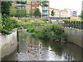
9
The Ravensbourne through Lewisham
Briefly released from its concrete trough, a 'naturalized' part of the river.
Image: © Robin Webster
Taken: 1 Oct 2011
0.07 miles
10
The River Ravensbourne in Cornmill Gardens (8)
For info about the gardens, see Lewisham Council's website http://www.lewisham.gov.uk/LeisureAndCulture/ParksAndRecreation/LocalParks/CornmillGardens.htm and http://www.therrc.co.uk/case_studies/cornmill%20gardens.pdf.
Image: © Mike Quinn
Taken: 5 Aug 2009
0.07 miles