IMAGES TAKEN NEAR TO
Wearside Road, LONDON, SE13 7EZ
Introduction
This page details the photographs taken nearby to Wearside Road, SE13 7EZ by members of the Geograph project.
The Geograph project started in 2005 with the aim of publishing, organising and preserving representative images for every square kilometre of Great Britain, Ireland and the Isle of Man.

There are currently over 7.5m images from over14,400 individuals and you can help contribute to the project by visiting https://www.geograph.org.uk
Image Map
Images are licensed for reuse under creativecommons.org/licenses/by-sa/2.0
Notes
- Clicking on the map will re-center to the selected point.
- The higher the marker number, the further away the image location is from the centre of the postcode.
Image Listing (225 Images Found)
Images are licensed for reuse under creativecommons.org/licenses/by-sa/2.0
Image
Details
Distance
1
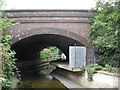
The River Ravensbourne near Engate Street, SE13 (7)
Image: © Mike Quinn
Taken: 5 Aug 2009
0.06 miles
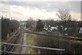
2
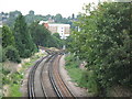
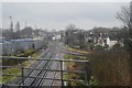
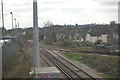
Railway junction north of Ladywell Road, SE13
Photo taken from the Ladywell Road bridge north of Ladywell station in Image
Image: © Mike Quinn
Taken: 5 Aug 2009
0.06 miles
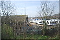
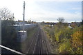
5
The River Ravensbourne near Wearside Road, SE13
The other side of the railway tracks to Image
Image: © Mike Quinn
Taken: 5 Aug 2009
0.07 miles
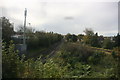
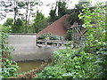
7
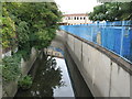
The River Ravensbourne near Wearside Road, SE13
Image: © Mike Quinn
Taken: 5 Aug 2009
0.07 miles