IMAGES TAKEN NEAR TO
William Close, LONDON, SE13 7DT
Introduction
This page details the photographs taken nearby to William Close, SE13 7DT by members of the Geograph project.
The Geograph project started in 2005 with the aim of publishing, organising and preserving representative images for every square kilometre of Great Britain, Ireland and the Isle of Man.

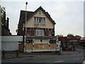
There are currently over 7.5m images from over14,400 individuals and you can help contribute to the project by visiting https://www.geograph.org.uk
Image Map
Images are licensed for reuse under creativecommons.org/licenses/by-sa/2.0
Notes
- Clicking on the map will re-center to the selected point.
- The higher the marker number, the further away the image location is from the centre of the postcode.
Image Listing (201 Images Found)
Images are licensed for reuse under creativecommons.org/licenses/by-sa/2.0
Image
Details
Distance
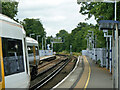
2
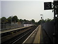
Looking east from Lewisham station
The original part of Lewisham station opened in 1849, on the North Kent Line which by-passed Greenwich because the Royal Observatory did not want their sensitive instruments disturbed by trains. This view looks along that original line towards Blackheath.
Image: © Marathon
Taken: 6 May 2011
0.05 miles
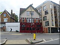
3
Lewisham 1st railway station (site), Greater London
Opened in 1849 by the South Eastern Railway on the line from London to Dartford, this station closed in 1857 when it was replaced by the current station immediately behind the camera position.
View east from the current station towards Blackheath and Dartford.
Image: © Nigel Thompson
Taken: 5 Jun 2019
0.05 miles

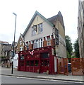
5
The Anchor, Lewisham
On Lewisham Road.
See Image] for sign.
Image: © JThomas
Taken: 24 Jun 2022
0.05 miles
6
The Anchor, Lewisham
On Lewisham Road.
See Image] for sign.
Image: © JThomas
Taken: 24 Jun 2022
0.05 miles
7
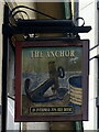
Sign for the Anchor, Lewisham
Image: © JThomas
Taken: 24 Jun 2022
0.05 miles
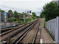
8
Looking east from platform 3, Lewisham
The North Kent line via Blackheath.
Image: © Robin Webster
Taken: 25 Jun 2011
0.05 miles
10
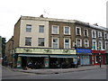
Maggie's Caf? & Restaurant, Lewisham Road, SE13
Image: © Mike Quinn
Taken: 5 Aug 2009
0.06 miles