IMAGES TAKEN NEAR TO
Silver Road, LONDON, SE13 7BJ
Introduction
This page details the photographs taken nearby to Silver Road, SE13 7BJ by members of the Geograph project.
The Geograph project started in 2005 with the aim of publishing, organising and preserving representative images for every square kilometre of Great Britain, Ireland and the Isle of Man.

There are currently over 7.5m images from over14,400 individuals and you can help contribute to the project by visiting https://www.geograph.org.uk
Image Map
Images are licensed for reuse under creativecommons.org/licenses/by-sa/2.0
Notes
- Clicking on the map will re-center to the selected point.
- The higher the marker number, the further away the image location is from the centre of the postcode.
Image Listing (172 Images Found)
Images are licensed for reuse under creativecommons.org/licenses/by-sa/2.0
Image
Details
Distance
1
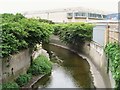
The River Ravensbourne near Silver Road, SE13
Image: © Mike Quinn
Taken: 5 Aug 2009
0.02 miles
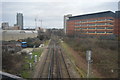
6
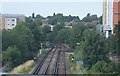
Lewisham: looking up towards the avoiding line from a Hayes train
Bound south for Hayes along the Ravensbourne valley, the railway passes under the loop built for non-stop trains to avoid Lewisham station and the associated junctions: the embankment passes behind the low building in the foreground.
Image: © Christopher Hilton
Taken: 7 Mar 2014
0.04 miles
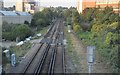
7
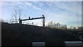
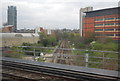
Lewisham: looking up towards the avoiding line from a Hayes train
Bound south for Hayes along the Ravensbourne valley, the railway passes under the loop built for non-stop trains to avoid Lewisham station and the associated junctions.
Image: © Christopher Hilton
Taken: 7 Mar 2014
0.04 miles
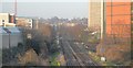
8
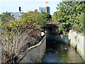
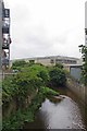
The Ravensbourne through Lewisham
Looking downstream. It passes under two railway bridges here - first the Courthill Loop (NCS) from Hayes line (LCH) to the main Dover Line (XTD), and then the Hayes line itself.
Image: © Robin Webster
Taken: 1 Oct 2011
0.04 miles