IMAGES TAKEN NEAR TO
Woodlands Street, LONDON, SE13 6TU
Introduction
This page details the photographs taken nearby to Woodlands Street, SE13 6TU by members of the Geograph project.
The Geograph project started in 2005 with the aim of publishing, organising and preserving representative images for every square kilometre of Great Britain, Ireland and the Isle of Man.

There are currently over 7.5m images from over14,400 individuals and you can help contribute to the project by visiting https://www.geograph.org.uk
Image Map
Images are licensed for reuse under creativecommons.org/licenses/by-sa/2.0
Notes
- Clicking on the map will re-center to the selected point.
- The higher the marker number, the further away the image location is from the centre of the postcode.
Image Listing (60 Images Found)
Images are licensed for reuse under creativecommons.org/licenses/by-sa/2.0
Image
Details
Distance
3
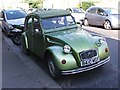
Vintage 1985 Citroen 2CV, Benin Street, Hither Green
Image: © Chris Whippet
Taken: 21 Aug 2015
0.03 miles
5
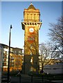
Park Fever Hospital
The water tower of the hospital, later called Hither Green Hospital http://www.lewisham.nhs.uk/history.php is now surrounded by new housing. Off Stainton Road.
Image: © Roger W Haworth
Taken: 25 Feb 2006
0.07 miles
7
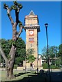
Hither Green Hospital Water Tower
One of the few original buildings on the redeveloped hospital site.
Image: © David Martin
Taken: 25 May 2011
0.12 miles