IMAGES TAKEN NEAR TO
St. Swithuns Road, LONDON, SE13 6RW
Introduction
This page details the photographs taken nearby to St. Swithuns Road, SE13 6RW by members of the Geograph project.
The Geograph project started in 2005 with the aim of publishing, organising and preserving representative images for every square kilometre of Great Britain, Ireland and the Isle of Man.

There are currently over 7.5m images from over14,400 individuals and you can help contribute to the project by visiting https://www.geograph.org.uk
Image Map
Images are licensed for reuse under creativecommons.org/licenses/by-sa/2.0
Notes
- Clicking on the map will re-center to the selected point.
- The higher the marker number, the further away the image location is from the centre of the postcode.
Image Listing (98 Images Found)
Images are licensed for reuse under creativecommons.org/licenses/by-sa/2.0
Image
Details
Distance
1
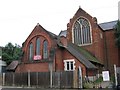
St Swithun's church and hall
The building in the foreground is the church hall (dating from 1884) and behind is the east end of the parish church (1893).
Image: © Stephen Craven
Taken: 13 Aug 2005
0.03 miles
2
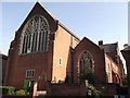
St. Swithun's Church, Hither Green
Large Grade II listed church on Hither Green Lane.
See http://www.britishlistedbuildings.co.uk/en-203304-church-of-st-swithun-lewisham for more details about the building.
See also Image
Image: © David Anstiss
Taken: 25 Sep 2011
0.06 miles
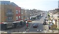
5
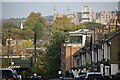
View down Ennersdale Road, with Kidbrooke in the distance
The railway bridge carries the Southeastern lines between Hither Green and Lewisham over Ennersdale Road. In the background is new-build housing close to Kidbrooke Station.
Image: © David Martin
Taken: 29 Oct 2022
0.10 miles
7
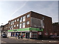
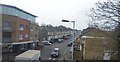
Hither Green Lane Co-Operative Supermarket
On the corner of Hither Green Lane (on the left) and Theodore Road (on the left).
Image: © David Anstiss
Taken: 25 Sep 2011
0.11 miles
9

Brindishe Green primary school, Hither Green
Brindishe Green primary school is governed jointly with another primary school nearby, Brindishe Lee.
Image: © Malc McDonald
Taken: 19 Mar 2011
0.11 miles
10
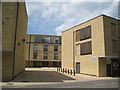
Hither Green: Gunton Mews SE13
If this is not brutalist architecture the photographer does not know what is. The only deference to humanity is the bird nesting box hung a third of the way up the wall to the left. Gunton Mews is off Nightingale Grove, so maybe that is the species of bird that the box is designed to attract... In late Victorian times the site was a plant nursery, more recently a photographic factory.
Image: © Nigel Cox
Taken: 30 Jun 2013
0.11 miles