IMAGES TAKEN NEAR TO
Mount Pleasant Road, LONDON, SE13 6HX
Introduction
This page details the photographs taken nearby to Mount Pleasant Road, SE13 6HX by members of the Geograph project.
The Geograph project started in 2005 with the aim of publishing, organising and preserving representative images for every square kilometre of Great Britain, Ireland and the Isle of Man.

There are currently over 7.5m images from over14,400 individuals and you can help contribute to the project by visiting https://www.geograph.org.uk
Image Map
Images are licensed for reuse under creativecommons.org/licenses/by-sa/2.0
Notes
- Clicking on the map will re-center to the selected point.
- The higher the marker number, the further away the image location is from the centre of the postcode.
Image Listing (18 Images Found)
Images are licensed for reuse under creativecommons.org/licenses/by-sa/2.0
Image
Details
Distance
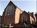
1
Hither Green Baptist Church
On the junction of Redford Road (on the left) and Theodore Road (on the left).
Image: © David Anstiss
Taken: 25 Sep 2011
0.06 miles
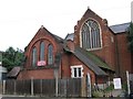
2
Holy Trinity Church, Ladywell
Small Zionists church on the corner of George Lane (in front) and Fordyce Road) (on the right).
Image: © David Anstiss
Taken: 25 Sep 2011
0.06 miles
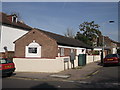
3
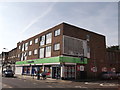
Hither Green Lane Co-Operative Supermarket
On the corner of Hither Green Lane (on the left) and Theodore Road (on the left).
Image: © David Anstiss
Taken: 25 Sep 2011
0.13 miles
4
St. Swithun's Church, Hither Green
Large Grade II listed church on Hither Green Lane.
See http://www.britishlistedbuildings.co.uk/en-203304-church-of-st-swithun-lewisham for more details about the building.
See also Image
Image: © David Anstiss
Taken: 25 Sep 2011
0.14 miles
5
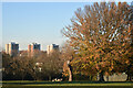
Mountsfield Park, with view of Lewisham Park Towers
Image: © David Martin
Taken: 10 Dec 2022
0.15 miles
6

The northern side of Mountsfield Park
Autumn colours are just beginning.
Image: © Bill Boaden
Taken: 11 Oct 2014
0.15 miles
7
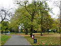
Path into Mountsfield Park
From Stainton Road.
Image: © Robin Webster
Taken: 30 Oct 2011
0.16 miles
8
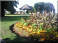
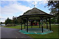
Mountsfield Park
Mountsfield Park takes its name from Mountsfield House, which in the mid 1840s became the home of Henry Stainton, an eminent entomologist. Mountsfield House was demolished in 1905, but remnants of the gardens still exist. The park was opened to the public in 1905. Beyond the flower bed in this photograph can be seen the bandstand and the new children's playground.
Image: © Marathon
Taken: 24 Aug 2010
0.17 miles
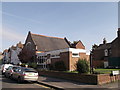
9
St Swithun's church and hall
The building in the foreground is the church hall (dating from 1884) and behind is the east end of the parish church (1893).
Image: © Stephen Craven
Taken: 13 Aug 2005
0.17 miles