IMAGES TAKEN NEAR TO
Callaghan Close, LONDON, SE13 5RR
Introduction
This page details the photographs taken nearby to Callaghan Close, SE13 5RR by members of the Geograph project.
The Geograph project started in 2005 with the aim of publishing, organising and preserving representative images for every square kilometre of Great Britain, Ireland and the Isle of Man.

There are currently over 7.5m images from over14,400 individuals and you can help contribute to the project by visiting https://www.geograph.org.uk
Image Map
Images are licensed for reuse under creativecommons.org/licenses/by-sa/2.0
Notes
- Clicking on the map will re-center to the selected point.
- The higher the marker number, the further away the image location is from the centre of the postcode.
Image Listing (160 Images Found)
Images are licensed for reuse under creativecommons.org/licenses/by-sa/2.0
Image
Details
Distance
4

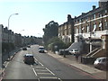
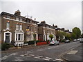
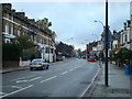
Glenton Road, Lee
Terraced housing on the north side of the street.
Image: © Stephen Craven
Taken: 1 Mar 2014
0.04 miles
6

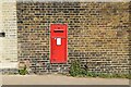
Gateway to Merchant Taylors Almshouses
The gateway is dated 1855, which is some 29 years later than the almshouses themselves. It is listed grade 2 (list entry number 1358480). A Victorian postbox is set into the brick wall adjacent to it.
Image: © Stephen Craven
Taken: 1 Mar 2014
0.04 miles
7
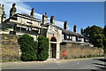
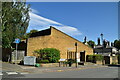
Entrance Gate, Merchant Taylor's Almshouses
Grade II listed.
Image: © N Chadwick
Taken: 17 May 2022
0.04 miles